IMAGES TAKEN NEAR TO
Groomsport Road, BANGOR, BT20 5NS
Introduction
This page details the photographs taken nearby to Groomsport Road, BT20 5NS by members of the Geograph project.
The Geograph project started in 2005 with the aim of publishing, organising and preserving representative images for every square kilometre of Great Britain, Ireland and the Isle of Man.

There are currently over 7.5m images from over14,400 individuals and you can help contribute to the project by visiting https://www.geograph.org.uk
Image Map
Images are licensed for reuse under creativecommons.org/licenses/by-sa/2.0
Notes
- Clicking on the map will re-center to the selected point.
- The higher the marker number, the further away the image location is from the centre of the postcode.
Image Listing (79 Images Found)
Images are licensed for reuse under creativecommons.org/licenses/by-sa/2.0
Image
Details
Distance
1
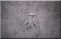
Bench Mark, Bangor
Cut bench mark on the Ballyholme Bridge on the Groomsport Road in Bangor.
The mark is 5.27 metres above MSL.
See also http://www.geograph.org.uk/search.php?i=11037856 for many other examples I have found.
Image: © Rossographer
Taken: 13 Mar 2010
0.06 miles
2
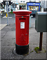
Postbox, Bangor
George VI postbox outside the Post Office at Ballyholme, Bangor (listed twice in the Royal Mail database as BT20 722 and BT20 772). Made by McDowell, Steven & Co. Ltd. of London and Falkirk.
Image: © Rossographer
Taken: 12 Dec 2009
0.08 miles
3
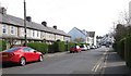
Sheridan Drive running South towards the junction with Groomsport Road
Sheridan Drive is a one way street.
Image: © Eric Jones
Taken: 17 Apr 2017
0.10 miles
4
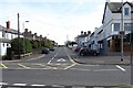
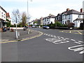
The junction of Windmill Road and Groomsport Road, Ballyholme
The image was taken from the southern end of Sheridan Drive.
Image: © Eric Jones
Taken: 17 Apr 2017
0.10 miles
5
The junction of Sheridan Drive and Groomsport Road
This junction is in the Ballyholme suburb of Bangor.
Image: © Eric Jones
Taken: 17 Apr 2017
0.10 miles
6
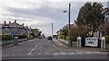
Morningside, Bangor
Residential street running from the Groomsport Road to Ballyholme beach in Bangor. Taken during the Covid-19 crisis, the banner on the right is in support of NHS workers. See also Image
Image: © Rossographer
Taken: 24 Mar 2020
0.10 miles
7
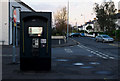
Telephone box, Bangor
BT "Street Talk 6" payphone outside shops on the Groomsport Road in Bangor.
Image: © Rossographer
Taken: 17 Apr 2012
0.10 miles
8
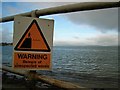
Beware of the waves!
Signs like these have been erected all along Belfast Lough, warning of the effects of unexpected waves. Most of these have been caused by high-speed ferry services operating out of Belfast such as the Stena Voyager HSS - see Image and Image
The Wikipedia article on the HSS vessels also includes some information on such wave incidents at http://en.wikipedia.org/wiki/High-speed_Sea_Service#Incidents
Image: © Rossographer
Taken: 26 Nov 2007
0.11 miles
9
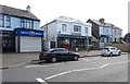
Suburban stores on Groomsport Road in Ballyholme
These include small branches of major chains including Boots the Chemists and the Co-op.
Image: © Eric Jones
Taken: 17 Apr 2017
0.11 miles
10
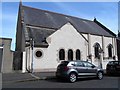
Most Holy Redeemer Roman Catholic Church in Sheridan Drive, Ballyholme
This is one of three churches within St Comgall's Parish. The main church is at Bangor and the third, also known as St Comgall's, is at Donaghadee.
Image: © Eric Jones
Taken: 17 Apr 2017
0.12 miles