IMAGES TAKEN NEAR TO
Waverley Drive, BANGOR, BT20 5LD
Introduction
This page details the photographs taken nearby to Waverley Drive, BT20 5LD by members of the Geograph project.
The Geograph project started in 2005 with the aim of publishing, organising and preserving representative images for every square kilometre of Great Britain, Ireland and the Isle of Man.

There are currently over 7.5m images from over14,400 individuals and you can help contribute to the project by visiting https://www.geograph.org.uk
Image Map
Images are licensed for reuse under creativecommons.org/licenses/by-sa/2.0
Notes
- Clicking on the map will re-center to the selected point.
- The higher the marker number, the further away the image location is from the centre of the postcode.
Image Listing (121 Images Found)
Images are licensed for reuse under creativecommons.org/licenses/by-sa/2.0
Image
Details
Distance
1
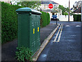
Old electricity box, Bangor
Another of the old electricity boxes found in Bangor. This one is on Waverley Drive. Again marked 'Borough of Bangor Electricity Department'. Made by Johnson & Phillips Electrical Engineers of London. Unlike other examples in the town, this one has been painted green. See also http://www.geograph.org.uk/search.php?i=9637907 for some related images.
Image: © Rossographer
Taken: 17 Apr 2012
0.08 miles
2
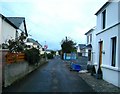
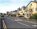
Along Lyle Road
Lyle Road runs parallel to Ballyholme Esplanade. An unusual street for the area in that there are no footpaths, I am guessing that it was once no more than a track or path that evolved slowly over time.
Image: © Rossographer
Taken: 27 Oct 2007
0.08 miles
3
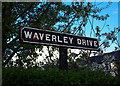
Street sign, Bangor
Street sign on Waverley Drive in Bangor. Probably original and dating from c1930, this is a cast iron sign, painted and mounted on wood. There are quite a few similar examples in the town, but many have been lost.
Image: © Rossographer
Taken: 17 Apr 2012
0.09 miles
4
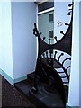
Unusual Porch, Godfrey Avenue
This new development on Godfrey Avenue has a very distinctive entrance!
Image: © Rossographer
Taken: 27 Oct 2007
0.09 miles
5
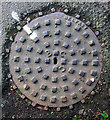
Manhole cover, Bangor
Manhole cover located on the Groomsport Road in Bangor. Marked 'Belfast' and with the letters 'BCC' but no foundry name. Possibly a cover originally destined for the streets of Belfast - BCC may have stood for Belfast City Corporation.
Image: © Rossographer
Taken: 17 Apr 2012
0.09 miles
7
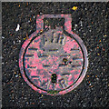
Air valve cover, Bangor
What appears to be an air valve cover on the Groomsport Road in Bangor. The cover is of a very similar size to Belfast Water Works covers such as Image
Image: © Rossographer
Taken: 17 Apr 2012
0.12 miles
8
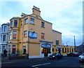
The Esplanade Bars
Long standing bars on Ballyholme Esplanade - the 'Esplanade' takes up the front ground floor; to the rear is an off-license and smaller bar, 'Gillespie's Place'. Upstairs is a restaurant.
Image: © Rossographer
Taken: 27 Oct 2007
0.12 miles
9
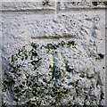
Bench Mark, Bangor
Cut bench mark located on a wall on the Groomsport Road in Bangor.
The mark is 8.64 metres above MSL.
Image: © Rossographer
Taken: 17 Apr 2012
0.13 miles
10
![Ballyholme Road, Bangor [2]](https://s3.geograph.org.uk/photos/65/86/658607_e31e2a0d_120x120.jpg)
Ballyholme Road, Bangor [2]
The other end of Ballyholme Road in Bangor from Image
The black and yellow post in the foreground is thought to be an indication of the limit of Bangor town at some point when it was erected - i.e. before Ballyholme was considered part of Bangor.
Image: © Rossographer
Taken: 13 Jan 2008
0.13 miles