IMAGES TAKEN NEAR TO
Third Avenue Bay Lands, BANGOR, BT20 5JX
Introduction
This page details the photographs taken nearby to Third Avenue Bay Lands, BT20 5JX by members of the Geograph project.
The Geograph project started in 2005 with the aim of publishing, organising and preserving representative images for every square kilometre of Great Britain, Ireland and the Isle of Man.

There are currently over 7.5m images from over14,400 individuals and you can help contribute to the project by visiting https://www.geograph.org.uk
Image Map
Images are licensed for reuse under creativecommons.org/licenses/by-sa/2.0
Notes
- Clicking on the map will re-center to the selected point.
- The higher the marker number, the further away the image location is from the centre of the postcode.
Image Listing (96 Images Found)
Images are licensed for reuse under creativecommons.org/licenses/by-sa/2.0
Image
Details
Distance
1
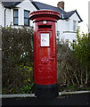
Postbox, Bangor
George V postbox on the corner of Hazeldene Drive and the Donaghadee Road in Bangor (BT20 519).
Image: © Rossographer
Taken: 12 Dec 2009
0.04 miles
2
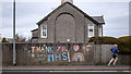
Chalk mural, Bangor
Taken during the Covid-19 pandemic, a message in support of the NHS chalked onto a wall on the Donaghadee Road, Bangor
Image: © Rossographer
Taken: 4 Apr 2020
0.05 miles
3
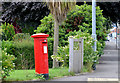
Pillar box BT20 519, Bangor (July 2014)
See Image Fortunately this GR pillar box (BT20 519) has not been replaced and is still at the corner of the Donaghadee Road and Hazeldene Drive. Previously seen in December 2009 Image
Image: © Albert Bridge
Taken: 15 Jul 2014
0.05 miles
4
![Ward Avenue [3]](https://s2.geograph.org.uk/photos/68/74/687422_be65de79_120x120.jpg)
Ward Avenue [3]
Looking along Ward Avenue from the Donaghadee Road just after sunset.
Image: © Rossographer
Taken: 11 Feb 2008
0.06 miles
5
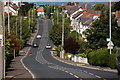
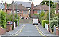
Donaghadee Road, Bangor
The Donaghadee Road runs from the centre of Bangor to a roundabout on the ring road. You may then go straight ahead to Donaghadee via the High Donaghadee Road or turn left for Donaghadee by the coast road. This is the view towards the town centre.
Image: © Albert Bridge
Taken: 13 Aug 2006
0.08 miles
6
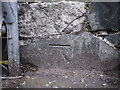
Bench Mark, Bangor
Cut bench mark on a wall on the Donaghadee Road in Bangor, close to the junction with Broadway.
The mark is 16.57 metres above MSL.
See also http://www.geograph.org.uk/search.php?i=11037856 for many other examples I have found.
Image: © Rossographer
Taken: 13 Mar 2010
0.09 miles
7
Fairview Gardens, Bangor
A cul-de-sac, on the northern side of the Donaghadee Road, developed in the mid-1950’s.
Image: © Albert Bridge
Taken: 17 Sep 2013
0.09 miles
8
![Ward Avenue [4]](https://s3.geograph.org.uk/photos/68/74/687431_083635b1_120x120.jpg)
Ward Avenue [4]
Ward Avenue runs right to left across the junction; the Ballyholme road bisects it. The house that used to stand behind the fence has recently been demolished. It stood just to the right of where Image was taken.
See also Image for a view of what was built here.
Image: © Rossographer
Taken: 11 Feb 2008
0.09 miles
9
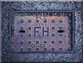
Fire hydrant cover, Bangor
Fire hydrant cover on Ballyholme Road. It is marked "PLC VINA" and "GRADE A". Further information on the foundry welcomed. Numerous in the area.
Image: © Rossographer
Taken: 2 Apr 2011
0.10 miles
10
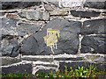
Bench Mark, Bangor
Cut bench mark on a wall on the Ballyholme Road in Bangor, close to the junction with Ward Avenue.
The mark is 15.36 metres above MSL.
See also http://www.geograph.org.uk/search.php?i=11037856 for many other examples I have found.
Image: © Rossographer
Taken: 21 Mar 2010
0.10 miles