IMAGES TAKEN NEAR TO
Sixth Avenue Bay Lands, BANGOR, BT20 5JU
Introduction
This page details the photographs taken nearby to Sixth Avenue Bay Lands, BT20 5JU by members of the Geograph project.
The Geograph project started in 2005 with the aim of publishing, organising and preserving representative images for every square kilometre of Great Britain, Ireland and the Isle of Man.

There are currently over 7.5m images from over14,400 individuals and you can help contribute to the project by visiting https://www.geograph.org.uk
Image Map
Images are licensed for reuse under creativecommons.org/licenses/by-sa/2.0
Notes
- Clicking on the map will re-center to the selected point.
- The higher the marker number, the further away the image location is from the centre of the postcode.
Image Listing (131 Images Found)
Images are licensed for reuse under creativecommons.org/licenses/by-sa/2.0
Image
Details
Distance
1
Fire hydrant cover, Bangor
Another example of a Glenfield & Kennedy fire hydrant cover - this one is located on Fifth Avenue in Bangor. A slightly different design to most in the town - Image shows the most common design.
Image: © Rossographer
Taken: 31 May 2011
0.05 miles
2
Ballyhome Road, Bangor
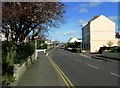
Ballyhome Road near the junction with the Seacliff Road (left) and Baylands First Avenue (right).
Image: © Rossographer
Taken: 28 Mar 2009
0.07 miles
3
![Old electricity box, Bangor [1]](https://s2.geograph.org.uk/photos/79/04/790470_d79ec141_120x120.jpg)
Old electricity box, Bangor [1]
An old electricity box on the Ballyholme Road in Bangor. It is marked 'Borough of Bangor Electricity Department' and is, I believe, still in use. See also Image
Image: © Rossographer
Taken: 3 May 2008
0.07 miles
4
![Old electricity box, Bangor [2]](https://s3.geograph.org.uk/photos/79/04/790475_f6e54ca8_120x120.jpg)
Old electricity box, Bangor [2]
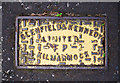
Detail of Image showing the badly weather logo. 'Borough of Bangor Electricity Department' is written around the edge; in the centre is what looks like a saint - probably St Comgall - with some indiscernible latin. It looks like an early coat of arms for Bangor predating the existing one shown at http://en.wikipedia.org/wiki/Image:Bangor_Crest.jpg Any info welcomed.
Image: © Rossographer
Taken: 3 May 2008
0.07 miles
5
House renovation, Bangor
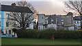
A fine late Victorian/Edwardian villa at 65 Ballyholme Road in Bangor being partially demolished. The house was built in 1901 as "Lauriston" by a Henry T. Fulton.
The frontage will be retained but everything else has been demolished to be rebuilt. The planning application states:
"Demolition of Dwelling except for the retention of the existing Front & Partial Side Facades and the Re-construction of the Dwelling to include a Rear Balcony, Roof Lantern and Juliette Balcony on the Eastern Side Elevation."
See also Image
Image: © Rossographer
Taken: 31 Jan 2020
0.08 miles
6
House renovation, Bangor
A fine late Victorian/Edwardian villa at 65 Ballyholme Road in Bangor being partially demolished. The house was built in 1901 as "Lauriston" by a Henry T. Fulton.
The frontage will be retained but everything else has been demolished to be rebuilt. The planning application states:
"Demolition of Dwelling except for the retention of the existing Front & Partial Side Facades and the Re-construction of the Dwelling to include a Rear Balcony, Roof Lantern and Juliette Balcony on the Eastern Side Elevation."
See also Image
Image: © Rossographer
Taken: 1 Feb 2020
0.08 miles
7
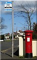
Postbox and Bus Stop, Bangor
George VI postbox alongside an 'Ulsterbus' bus stop on the Ballyholme Road in Bangor (BT20 714).
Image: © Rossographer
Taken: 28 Mar 2009
0.08 miles
8
![Starlings, Bangor [1]](https://s1.geograph.org.uk/photos/76/29/762961_2f83d8ee_120x120.jpg)
Starlings, Bangor [1]
A pair of starlings at Ballyholme in Bangor.
Image: © Rossographer
Taken: 13 Apr 2008
0.08 miles
9
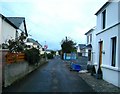
Along Lyle Road
Lyle Road runs parallel to Ballyholme Esplanade. An unusual street for the area in that there are no footpaths, I am guessing that it was once no more than a track or path that evolved slowly over time.
Image: © Rossographer
Taken: 27 Oct 2007
0.08 miles
10
![Starlings, Bangor [2]](https://s1.geograph.org.uk/photos/76/29/762965_4d6c76c3_120x120.jpg)
Starlings, Bangor [2]
A solitary starling at Ballyholme. Although apparently in decline, these birds still seem numerous everywhere I go.
Image: © Rossographer
Taken: 13 Apr 2008
0.08 miles