IMAGES TAKEN NEAR TO
Ward Avenue, BANGOR, BT20 5HW
Introduction
This page details the photographs taken nearby to Ward Avenue, BT20 5HW by members of the Geograph project.
The Geograph project started in 2005 with the aim of publishing, organising and preserving representative images for every square kilometre of Great Britain, Ireland and the Isle of Man.

There are currently over 7.5m images from over14,400 individuals and you can help contribute to the project by visiting https://www.geograph.org.uk
Image Map
Images are licensed for reuse under creativecommons.org/licenses/by-sa/2.0
Notes
- Clicking on the map will re-center to the selected point.
- The higher the marker number, the further away the image location is from the centre of the postcode.
Image Listing (143 Images Found)
Images are licensed for reuse under creativecommons.org/licenses/by-sa/2.0
Image
Details
Distance
1
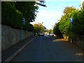
Ward Avenue
Looking towards the Seacliff Road. Unlike nearby Ballyholme Road Image, Ward Ave has not (yet) been touched by the dreaded developers.
Image: © Rossographer
Taken: 6 Oct 2007
0.04 miles
![Ward Avenue [2]](https://s3.geograph.org.uk/photos/58/52/585239_0f7ecf41_120x120.jpg)
3
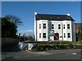
New apartments, Bangor
A new apartment block built on the corner of the Ballyholme Road (right to left) and Ward Avenue in Bangor. This replaces a fine Victorian villa that stood on the site. See also Image for a view taken before construction began.
Image: © Rossographer
Taken: 28 Mar 2009
0.05 miles
4
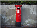
Postbox, Bangor
George V postbox on the Ballyholme Road in Bangor (BT20 236). The makers name - Carron & Company, Stirlingshire - is just about visible at the base.
Image: © Rossographer
Taken: 8 Nov 2009
0.07 miles
5
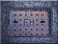
Fire hydrant cover, Bangor
Fire hydrant cover on Ballyholme Road. It is marked "PLC VINA" and "GRADE A". Further information on the foundry welcomed. Numerous in the area.
Image: © Rossographer
Taken: 2 Apr 2011
0.07 miles
6
Bench Mark, Bangor
Cut bench mark on a wall on the Ballyholme Road in Bangor, close to the junction with Ward Avenue.
The mark is 15.36 metres above MSL.
See also http://www.geograph.org.uk/search.php?i=11037856 for many other examples I have found.
Image: © Rossographer
Taken: 21 Mar 2010
0.07 miles
7
![Ward Avenue [4]](https://s3.geograph.org.uk/photos/68/74/687431_083635b1_120x120.jpg)
Ward Avenue [4]
Ward Avenue runs right to left across the junction; the Ballyholme road bisects it. The house that used to stand behind the fence has recently been demolished. It stood just to the right of where Image was taken.
See also Image for a view of what was built here.
Image: © Rossographer
Taken: 11 Feb 2008
0.08 miles
8
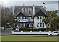
Cairn Bay Lodge, Bangor
Cairn Bay Lodge is a large guesthouse and cafe on the Seacliff Road in Bangor. Taken during the Covid-19 pandemic, the banner is in support of NHS workers.
Image: © Rossographer
Taken: 3 Apr 2020
0.09 miles
9
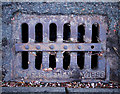
Gully grating, Bangor
A grating on Ballyholme Road in Bangor. The inscription is very worn and only "Belfast Foundry 1896" is still visible. This is enough, however, to indicate that this is another example from Houston and Hamilton similar to Image - there are letters just visible beneath the iron strip running down the middle that would indicate that this is also cast in the "County Down Pattern".
This is the only example in the area - all other gratings are much more modern.
Image: © Rossographer
Taken: 2 Apr 2011
0.09 miles
10
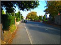
Ballyholme Road
Looking towards Ballyholme Esplanade. A very pleasant road that is sadly being destroyed by redevelopments.
Image: © Rossographer
Taken: 6 Oct 2007
0.10 miles