IMAGES TAKEN NEAR TO
Hamilton Road, BANGOR, BT20 5DB
Introduction
This page details the photographs taken nearby to Hamilton Road, BT20 5DB by members of the Geograph project.
The Geograph project started in 2005 with the aim of publishing, organising and preserving representative images for every square kilometre of Great Britain, Ireland and the Isle of Man.

There are currently over 7.5m images from over14,400 individuals and you can help contribute to the project by visiting https://www.geograph.org.uk
Image Map
Images are licensed for reuse under creativecommons.org/licenses/by-sa/2.0
Notes
- Clicking on the map will re-center to the selected point.
- The higher the marker number, the further away the image location is from the centre of the postcode.
Image Listing (198 Images Found)
Images are licensed for reuse under creativecommons.org/licenses/by-sa/2.0
Image
Details
Distance
1
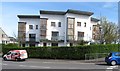
Town Houses at the corner of Hamilton and Donaghadee Roads
Image: © Eric Jones
Taken: 17 Apr 2017
0.03 miles
2
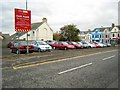
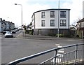
A VERY important car park
Car park on the corner of Clifton Road at the junction with High Street / Ballyholme Road.
The house 'Mount Herald' used to sit on this site. Built in the 1860s Mount Herald was a fine house but was also quite important historically. In April 1914, 216 tons of arms were purchased in Hamburg and were transferred to the 'SS Clydevalley' and smuggled into Ulster at Larne, Bangor and Donaghadee before being distributed to arms dumps all over the North of Ireland - these were for members of the recently formed 'Ulster Volunteer Force', formed against the impeding threat of Home Rule in Ireland. Some of the weapons landed in Bangor from the Clydevalley were displayed in the yard of Mount Herald; there are photographs of local 'C' company UVF parading in the yard of Mount Herald (see the book here http://www.amazon.co.uk/Bangor-Historic-Photographs-1870-1914-Heritage/dp/0946872546/ref=sr_11_1/202-1768914-9960626?ie=UTF8&qid=1192984959&sr=11-1 ).
Now, and whatever your political views, I believe that this was arguably a house of important heritage and worth saving for posterity. Not so my local council who clearly thought that a car park was vital to this part of Bangor and demolished Mount Herald in 1982. I can but therefore conclude that this is a VERY important car park!
Image: © Rossographer
Taken: 21 Oct 2007
0.03 miles
3
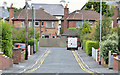
Fairview Gardens, Bangor
A cul-de-sac, on the northern side of the Donaghadee Road, developed in the mid-1950’s.
Image: © Albert Bridge
Taken: 17 Sep 2013
0.03 miles
4
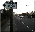
Old roadsign, Ballyholme Road
An old sign that still sits on the Ballyholme Road.
Image: © Rossographer
Taken: 11 Feb 2008
0.03 miles
5
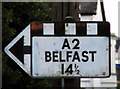
Pre-Worboys sign, Ballyholme Road
Old roadsign, predating the modern variety introduced in the late 1960's as a result of recommendations based on the report of The Worboys Committee which reformed signing on all roads other than motorways. This is a close-up of Image
Image: © Rossographer
Taken: 7 Jul 2009
0.04 miles
6
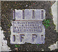
Fire hydrant cover, Bangor
A fire hydrant cover on the Donaghadee Road in Bangor. It was cast in the foundry of "J Blakeborough & Sons, Manufacturers, Brighouse". It is much smaller than most fire hydrant covers, and measures approximately 6 inches across. See also Image, Image and Image
Image: © Rossographer
Taken: 20 May 2011
0.05 miles
7
Taylor's Corner Apartments at the junction of Donaghadee Road and Hamilton Road
Image: © Eric Jones
Taken: 17 Apr 2017
0.05 miles
8
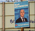
Election Poster, Bangor
Poster for Mark Brotherston, the Conservative Party candidate in North Down.
Image: © Rossographer
Taken: 18 Apr 2015
0.05 miles
9
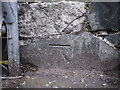
Bench Mark, Bangor
Cut bench mark on a wall on the Donaghadee Road in Bangor, close to the junction with Broadway.
The mark is 16.57 metres above MSL.
See also http://www.geograph.org.uk/search.php?i=11037856 for many other examples I have found.
Image: © Rossographer
Taken: 13 Mar 2010
0.05 miles
10
The former Savoy Hotel in Donaghadee Road, Bangor
Image: © Eric Jones
Taken: 17 Apr 2017
0.05 miles