IMAGES TAKEN NEAR TO
Lismore Avenue, BANGOR, BT20 4XD
Introduction
This page details the photographs taken nearby to Lismore Avenue, BT20 4XD by members of the Geograph project.
The Geograph project started in 2005 with the aim of publishing, organising and preserving representative images for every square kilometre of Great Britain, Ireland and the Isle of Man.

There are currently over 7.5m images from over14,400 individuals and you can help contribute to the project by visiting https://www.geograph.org.uk
Image Map
Images are licensed for reuse under creativecommons.org/licenses/by-sa/2.0
Notes
- Clicking on the map will re-center to the selected point.
- The higher the marker number, the further away the image location is from the centre of the postcode.
Image Listing (19 Images Found)
Images are licensed for reuse under creativecommons.org/licenses/by-sa/2.0
Image
Details
Distance
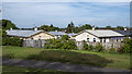
1
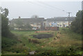
Houses, Bangor
Houses and flats at Lisnabreen in Bangor. The dark patch of ground marks the remains of an 11th night bonfire (similar to Image). Taken on a very misty morning.
Image: © Rossographer
Taken: 29 Jul 2022
0.01 miles
2

'Anti-vax' message, Bangor
Sticker on a telegraph pole at Castle Park, Bangor. One of many.
Clearly part of the 'anti-vax' https://www.bbc.co.uk/news/health-33774181 and Covid-19 denial movement.
Image: © Rossographer
Taken: 23 Jul 2021
0.04 miles
3

Supermarket sign, Bangor
Sign on the 'Lidl' supermarket in Bangor Image
Image: © Rossographer
Taken: 4 May 2015
0.12 miles
4
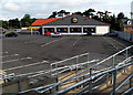
'Lidl' supermarket, Bangor
Lidl store located on the Bloomfield Road in Bangor.
Image: © Rossographer
Taken: 16 Jul 2009
0.14 miles
5
Mural, Bangor
Pride of Whitehill flute band mural on a gable wall at the Skipperstone Road, Bangor.
Image: © Rossographer
Taken: 16 Jun 2020
0.15 miles
6

Spider's web, Bangor
Dew drop covered web at Castle Park in Bangor.
Image: © Rossographer
Taken: 29 Jul 2022
0.15 miles
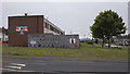
7
Prefab housing, Bangor
Aluminium prefabricated housing off the Bloomfield Road in Bangor. Built shortly after the end of WW2 and still in use today. See also https://www.flickr.com/photos/adambangor/5874955464/in/photolist-aYTLP6-fvhdf8-9PHU9e-bvuX5H-4r7rmU-hc3H2e-cZ9Kf1-dP79oC-fvwzzL-imhZyW-9X9FzA-dByeao-bAYxmJ-fvhgHX-aqGpJR-9NS6rA-bAp8R2-64bWvw-aqGq9t-jubV73-6e8Zsx-jubd5T-cbNp95-3JihY-9xGu3x-dBt8Ga-5yiiDV-4bbzUi-5ynEAf-bAYxgW-dQ3mUJ-2UrsSH-avARah-woipt5-6LBzHD-xVULSM-xTSyxj/ .
Image: © Rossographer
Taken: 20 May 2020
0.17 miles
8
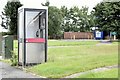
Telephone box, Bangor (July 2015)
A KX100 telephone box at Skipperstone Park.
Image: © Albert Bridge
Taken: 21 Jul 2015
0.17 miles
9
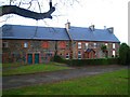
'Home Farm', Bangor
Located beside Valentine Playing Fields and built c1850, these houses were probably originally associated with the nearby Bangor Castle Image
Update: totally demolished in 2011 to make way for the new leisure centre.
Image: © Rossographer
Taken: 11 Nov 2007
0.21 miles
10
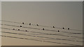
Swallows, Bangor
Late summer and the chattering swallows have begun to gather on the telegraph wires at dawn and dusk, preparing themselves for the long flight south.
Image: © Rossographer
Taken: 25 Aug 2019
0.21 miles