IMAGES TAKEN NEAR TO
Bloomfield Road, BANGOR, BT20 4UH
Introduction
This page details the photographs taken nearby to Bloomfield Road, BT20 4UH by members of the Geograph project.
The Geograph project started in 2005 with the aim of publishing, organising and preserving representative images for every square kilometre of Great Britain, Ireland and the Isle of Man.

There are currently over 7.5m images from over14,400 individuals and you can help contribute to the project by visiting https://www.geograph.org.uk
Image Map
Images are licensed for reuse under creativecommons.org/licenses/by-sa/2.0
Notes
- Clicking on the map will re-center to the selected point.
- The higher the marker number, the further away the image location is from the centre of the postcode.
Image Listing (66 Images Found)
Images are licensed for reuse under creativecommons.org/licenses/by-sa/2.0
Image
Details
Distance
1
Pillar box, Bangor
EIIR pillar box (BT20 156) on the eastern side of the Bloomfield Road, just outward of Pitcairn Avenue.
Image: © Albert Bridge
Taken: 5 Apr 2012
0.01 miles
2
2019 Election poster, Bangor
Stephen Farry for the Alliance Party on the Bloomfield Road in Bangor.
Image: © Rossographer
Taken: 8 Dec 2019
0.05 miles
3

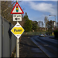
2019 Election poster, Bangor
Alex Easton for the Democratic Unionist Party at the junction of the Bloomfield and Gransha roads in Bangor (Stephen Farry for the Alliance Party is behind).
Image: © Rossographer
Taken: 8 Dec 2019
0.07 miles
4

Plum blossom, Bangor
Emerging plum blossom on a tree; the fly is also warming up in the strong sun.
Image: © Rossographer
Taken: 2 Apr 2021
0.07 miles
5
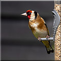
Goldfinch, Bangor
European goldfinch (Carduelis carduelis) on a feeder in Bangor.
Image: © Rossographer
Taken: 7 Apr 2020
0.08 miles
6
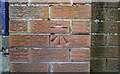
Bench Mark, Bangor
Cut bench mark at the bottom of a wall at the end of Bloomfield Road at the junction with Gransha Road in Bangor.
See also http://www.geograph.org.uk/search.php?i=11037856 for many other examples I have found.
Image: © Rossographer
Taken: 5 Mar 2010
0.08 miles
7
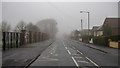
Bloomfield Road, Bangor
Bloomfield Road on a foggy Christmas morning.
Image: © Rossographer
Taken: 25 Dec 2018
0.09 miles
8
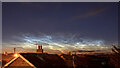
Noctilucent clouds
Noctilucent clouds https://en.m.wikipedia.org/wiki/Noctilucent_cloud as seen from Bangor, County Down, looking north. Image taken at 20 minutes past midnight - they were extraordinarily bright, even in a built-up area with a huge amount of light pollution.
Image: © Rossographer
Taken: 13 Jul 2021
0.10 miles
9
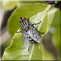
Fly, Bangor
Macro of a fly on hedging in Bangor. Possibly a Flesh Fly https://en.wikipedia.org/wiki/Flesh_fly but clarification welcome.
Image: © Rossographer
Taken: 24 Apr 2020
0.11 miles
10
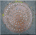
Manhole cover, Bangor
Manhole cover located on the Gransha Road, Bangor. It was cast by the Grahamston Iron Company of Falkirk which traded from 1868-1993.
Image: © Rossographer
Taken: 28 Oct 2010
0.11 miles