
IMAGES TAKEN NEAR TO
Dellmount Park, BANGOR, BT20 4UA
Introduction
This page details the photographs taken nearby to Dellmount Park, BT20 4UA by members of the Geograph project.
The Geograph project started in 2005 with the aim of publishing, organising and preserving representative images for every square kilometre of Great Britain, Ireland and the Isle of Man.

There are currently over 7.5m images from over14,400 individuals and you can help contribute to the project by visiting https://www.geograph.org.uk
Image Map
Images are licensed for reuse under creativecommons.org/licenses/by-sa/2.0
Notes
- Clicking on the map will re-center to the selected point.
- The higher the marker number, the further away the image location is from the centre of the postcode.
Image Listing (15 Images Found)
Images are licensed for reuse under creativecommons.org/licenses/by-sa/2.0
Image
Details
Distance
1
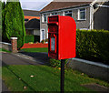
Postbox, Bangor
Post mounted postbox on the Gransha Road in Bangor (BT20 321). The box is unusual in that it has no royal cypher, although it does feature a crown. The box was manufactured by Machan Engineering of Denny in Stirlingshire. See also Image
Image: © Rossographer
Taken: 2 Nov 2011
0.10 miles
2
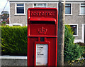
Postbox, Bangor
Post mounted postbox on the Gransha Road in Bangor (BT20 321). The box is unusual in that it has no royal cypher, although it does feature a crown. The box was manufactured by Machan Engineering of Denny in Stirlingshire. See also Image
Image: © Rossographer
Taken: 2 Nov 2011
0.10 miles
3
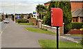
Letter box, Bangor
See Image (November 2011). The same box (BT20 321 - without a Royal cypher) in its setting alongside the Gransha Road.
Image: © Albert Bridge
Taken: 5 Apr 2012
0.10 miles
4
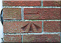
Bench Mark, Bangor
Cut bench mark on a wall on the Gransha Road in Bangor.
The mark is 17.29 metres above MSL.
Image: © Rossographer
Taken: 2 Nov 2011
0.11 miles
5
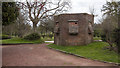
Pillbox, Bangor
Pillbox on Bangor Golf Course, close to the fifth tee. It is probably what was known as a 'Type 22' and had rifle ports offering lines of sight in different directions - these have all been partially bricked up. I believe it was being used as a store by the green keepers but now appears to be sealed.
Image: © Rossographer
Taken: 4 Apr 2020
0.16 miles
6
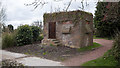
Pillbox, Bangor
Pillbox on Bangor Golf Course, close to the fifth tee. It is probably what was known as a 'Type 22' and had rifle ports offering lines of sight in different directions - these have all been partially bricked up. I believe it was being used as a store by the green keepers but now appears to be sealed.
Image: © Rossographer
Taken: 4 Apr 2020
0.16 miles
7
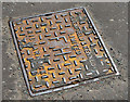
Glenfield & Kennedy fire hydrant cover, Bangor
A Glenfield & Kennedy fire hydrant cover on the Gransha Road, near the corner of the Fairfield Road.
Image: © Albert Bridge
Taken: 21 May 2013
0.19 miles
8
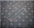
Manhole cover, Bangor
Manhole cover located on Fairfield Road, Bangor. It is marked "MacNaughton Craigavon" - any information on this company is welcomed.
Image: © Rossographer
Taken: 28 Oct 2010
0.20 miles
9

Greenbottle, Bangor
Greenbottle fly (Lucilia sericata) on hedging in Bangor.
Image: © Rossographer
Taken: 26 May 2020
0.20 miles
10

Red Admiral, Bangor
Red Admiral butterfly (Vanessa atalanta) on hedging at Bangor.
Image: © Rossographer
Taken: 26 May 2020
0.20 miles