IMAGES TAKEN NEAR TO
Castle Cottages, BANGOR, BT20 4SZ
Introduction
This page details the photographs taken nearby to Castle Cottages, BT20 4SZ by members of the Geograph project.
The Geograph project started in 2005 with the aim of publishing, organising and preserving representative images for every square kilometre of Great Britain, Ireland and the Isle of Man.

There are currently over 7.5m images from over14,400 individuals and you can help contribute to the project by visiting https://www.geograph.org.uk
Image Map
Images are licensed for reuse under creativecommons.org/licenses/by-sa/2.0
Notes
- Clicking on the map will re-center to the selected point.
- The higher the marker number, the further away the image location is from the centre of the postcode.
Image Listing (203 Images Found)
Images are licensed for reuse under creativecommons.org/licenses/by-sa/2.0
Image
Details
Distance
1
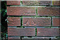
Bench Mark, Bangor
Cut bench mark at the bottom of a wall at the corner of Castle Street and Castle Park Avenue in Bangor.
See also http://www.geograph.org.uk/search.php?i=11037856 for many other examples I have found.
Image: © Rossographer
Taken: 5 Mar 2010
0.01 miles
2
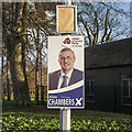
2019 Election poster, Bangor
Alan Chambers for the Ulster Unionist Party on Castle Street in Bangor.
Image: © Rossographer
Taken: 8 Dec 2019
0.02 miles
3
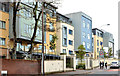
Castle Gate, Bangor
A recent development of stylish houses and apartments at Castle Street. A property website, checked on the day of submission, shows that some are still being offered for sale. This photograph appears as a matter of record only. I have no connection with any of the parties involved in the development or sale.
Image: © Albert Bridge
Taken: 15 Nov 2012
0.02 miles
4
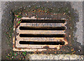
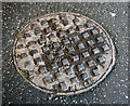
Grating, Bangor
Grating cover cast by the Portadown Foundry located in Ward Park, Bangor. See also Image for a related image.
Image: © Rossographer
Taken: 22 Apr 2012
0.03 miles
5
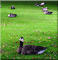
Geese, Ward Park, Bangor
Geese in Ward Park in Bangor. In the foreground is what appears to be a GreylagxCanada hybrid goose and, judging by the white around the bill, there may be something else in its history as well, or possibly just a domestic origin to the Greylag parent. The geese in the background all look like pure Greylags.
Image: © Rossographer
Taken: 3 Aug 2008
0.03 miles
6

Covid advert, Bangor
Static government Covid awareness advert on a bus shelter at Castle Street, Bangor.
Image: © Rossographer
Taken: 7 Feb 2021
0.03 miles
7
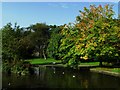
Ward Park
Looking along the little river and trees in Ward Park. Most trees have kept their greenery apart from the horse chestnut on the right, although it was also looking a little ill and had already lost a lot of leaves.
Image: © Rossographer
Taken: 21 Sep 2008
0.03 miles
8
Manhole cover, Bangor
Manhole cover on the Gransha Road in Bangor. It is marked 'Kesgas' and the British Standard BS 497. Further information welcomed. Image shows the 'Kesgas' name in detail.
Image: © Rossographer
Taken: 17 May 2012
0.04 miles
9
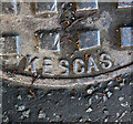
Manhole cover, Bangor
Detail of the manhole cover on the Gransha Road in Bangor seen in Image It is marked 'Kesgas' and the British Standard BS 497. Further information welcomed.
Image: © Rossographer
Taken: 17 May 2012
0.04 miles
10
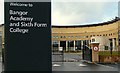
Bangor Academy and Sixth Form College
Recently opened school on Castle Park Avenue - see Image for a view of the site during construction.
Image: © Rossographer
Taken: 28 Oct 2008
0.04 miles