IMAGES TAKEN NEAR TO
Gilbert Crescent, BANGOR, BT20 4PE
Introduction
This page details the photographs taken nearby to Gilbert Crescent, BT20 4PE by members of the Geograph project.
The Geograph project started in 2005 with the aim of publishing, organising and preserving representative images for every square kilometre of Great Britain, Ireland and the Isle of Man.

There are currently over 7.5m images from over14,400 individuals and you can help contribute to the project by visiting https://www.geograph.org.uk
Image Map
Images are licensed for reuse under creativecommons.org/licenses/by-sa/2.0
Notes
- Clicking on the map will re-center to the selected point.
- The higher the marker number, the further away the image location is from the centre of the postcode.
Image Listing (12 Images Found)
Images are licensed for reuse under creativecommons.org/licenses/by-sa/2.0
Image
Details
Distance
1
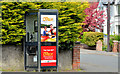
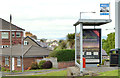
Telephone box, Bangor
A BT telephone box, at the corner of Bellevue and the Donaghadee Road (foreground).
Image: © Albert Bridge
Taken: 21 May 2013
0.04 miles
2
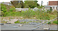
"Wrights" shop, Bangor (site of)
See Image (March 2008). The shop was subsequently demolished leaving this vacant site, close to the corner of the Donaghadee Road (foreground) and Summerhill Park.
Image: © Albert Bridge
Taken: 21 May 2013
0.07 miles
3
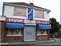
Derelict Shop, Bangor
'Wrights' shop on the Donaghadee Road thrived for many years. Sadly, after the retirement of the owners, it changed hands and, despite remaining open as a shop for a short time, it closed and will now be demolished and redeveloped.
Image: © Rossographer
Taken: 22 Mar 2008
0.10 miles
4
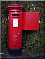
Postbox, Bangor
Elizabeth II postbox on the Donaghadee Road in Bangor (BT20 754).
Image: © Rossographer
Taken: 12 Dec 2009
0.11 miles
5
Bus shelter, Thornleigh, Bangor
A modern “Adshel” shelter at the Thornleigh (left) bus stop on the Donaghadee Road. Apparently it replaced a brick one – something which merits a commemorative plaque (to the right of the red seat) – see Image
Image: © Albert Bridge
Taken: 21 May 2013
0.13 miles
6
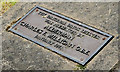
Thornleigh bus shelter plaque, Bangor
See Image The commemorative ground plaque which reads “The original brick shelter was presented by Alderman Charles F Milligan OBE January 1971”.
Image: © Albert Bridge
Taken: 21 May 2013
0.13 miles
7
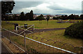
Brice Park, Bangor
Brice Park, located off the Donaghadee Road in Bangor. A plaque records that the land here was donated to the borough of Bangor by Frederick J. Brice JP and James F. Brice - see Image
Image: © Rossographer
Taken: 20 Jun 2009
0.13 miles
8
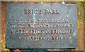
Plaque, Brice Park
Plaque in Brice Park Image recording that the land here was donated to the borough of Bangor by Frederick J. Brice JP and James F. Brice.
Image: © Rossographer
Taken: 20 Jun 2009
0.15 miles
9
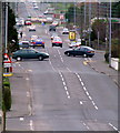
Donaghadee Road, Bangor
Looking out of Bangor towards the East Circular Ring Road and the road to Donaghadee beyond.
Image: © Rossographer
Taken: 22 Mar 2008
0.18 miles
10
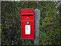
Postbox, Bangor
Post mounted Elizabeth II postbox on the Donaghadee Road in Bangor (BT20 868). Made by Carron of Falkirk .
Image: © Rossographer
Taken: 12 Dec 2009
0.20 miles