IMAGES TAKEN NEAR TO
St. Malachys Way, BANGOR, BT20 4JF
Introduction
This page details the photographs taken nearby to St. Malachys Way, BT20 4JF by members of the Geograph project.
The Geograph project started in 2005 with the aim of publishing, organising and preserving representative images for every square kilometre of Great Britain, Ireland and the Isle of Man.

There are currently over 7.5m images from over14,400 individuals and you can help contribute to the project by visiting https://www.geograph.org.uk
Image Map
Images are licensed for reuse under creativecommons.org/licenses/by-sa/2.0
Notes
- Clicking on the map will re-center to the selected point.
- The higher the marker number, the further away the image location is from the centre of the postcode.
Image Listing (224 Images Found)
Images are licensed for reuse under creativecommons.org/licenses/by-sa/2.0
Image
Details
Distance
1
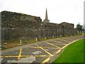
St Malachy's Wall
This wall is thought to be the oldest man-made structure in Bangor, dating from the 13th Century. It is believed to be part of the medieval monastery built by St Malachy in around 1140.
Currently surrounded by a fence as it is in danger of collapsing - nobody seems too sure about how best to preserve it. See http://www.qub.ac.uk/schools/CentreforArchaeologicalFieldworkCAF/Reports/DataStructureReports/Filetoupload,64282,en.pdf for a detailed investigation.
Image: © Rossographer
Taken: 21 Oct 2007
0.01 miles
2
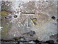
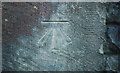
Bench Mark, Bangor
Cut bench mark at the western tip of St Malachy's Wall Image close to Bangor Abbey.
See also http://www.geograph.org.uk/search.php?i=11037856 for many other examples I have found.
Image: © Rossographer
Taken: 7 Mar 2010
0.02 miles
3
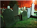
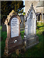
Gravestones, Bangor Abbey
Gravestones in the churchyard of Bangor Abbey. Taken at night, the lights behind belong to the Health & Social Services building adjacent to the church.
The grave on the left records the death of a Robert Hamilton of Stockbridge (Donaghadee) who died in 1792 aged 92 and also his wife Ann Leckey (Hamilton) who died in 1800, also aged 92. The headstone also records the names of other members of the same family buried here.
Image: © Rossographer
Taken: 13 Dec 2010
0.03 miles
4
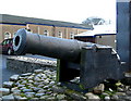
Little cannon, Bangor Abbey
Everyone in Bangor knows about the U-Boat gun in Ward Park Image but most forget about the other naval gun on public display, situated in the car park beside Bangor Abbey.
It is a little cannon taken from the Ulster Privateer 'The Amazon' that was wrecked in Ballyholme Bay on 23rd February 1780. See Image for full details.
Image: © Rossographer
Taken: 2 Jan 2008
0.03 miles
5
Bench Mark, Bangor
Cut bench mark located on the southern wall of Bangor Abbey Image This mark was cut in the early 1970s when it was discovered that a flush bracket, numbered OSBM 3468, which had been sited on the church had been destroyed.
See also http://www.geograph.org.uk/search.php?i=11037856 for many other examples I have found.
Image: © Rossographer
Taken: 7 Mar 2010
0.03 miles
6
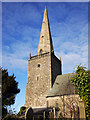
Spire, Bangor Abbey
The spire of Bangor Abbey Image
Image: © Rossographer
Taken: 18 Dec 2009
0.04 miles
7
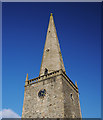
Steeple, Bangor Abbey
The steeple of Bangor Abbey Image
The tower dates from the 15th Century, the spire being added in the late 17th Century. An inscription inside the tower reads "This steepel was raised anno 1693 Io Blackwood Io Cleland Church wardens."
Image: © Rossographer
Taken: 7 Mar 2010
0.04 miles
8
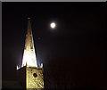
Spire, Bangor Abbey
The illuminated spire of Bangor Abbey Image with the waxing moon rising behind.
Image: © Rossographer
Taken: 13 Dec 2010
0.04 miles
9
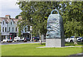
The 'Bangor Bell' sculpture, Bangor
The recently erected sculpture close to Bangor Abbey.
Image: © Rossographer
Taken: 7 Jul 2016
0.04 miles
10
Gravestones, Bangor Abbey churchyard
The churchyard at Bangor Abbey contains many elaborate Victorian monuments alongside the more simplistic 18th century headstones. The one on the left here records the death of a Hugh Campbell who, aged 33, was drowned at Melbourne on the 7th April 1875.
Image: © Rossographer
Taken: 18 Dec 2009
0.04 miles