IMAGES TAKEN NEAR TO
The Crescent, BANGOR, BT20 4DX
Introduction
This page details the photographs taken nearby to The Crescent, BT20 4DX by members of the Geograph project.
The Geograph project started in 2005 with the aim of publishing, organising and preserving representative images for every square kilometre of Great Britain, Ireland and the Isle of Man.

There are currently over 7.5m images from over14,400 individuals and you can help contribute to the project by visiting https://www.geograph.org.uk
Image Map
Images are licensed for reuse under creativecommons.org/licenses/by-sa/2.0
Notes
- Clicking on the map will re-center to the selected point.
- The higher the marker number, the further away the image location is from the centre of the postcode.
Image Listing (17 Images Found)
Images are licensed for reuse under creativecommons.org/licenses/by-sa/2.0
Image
Details
Distance
1
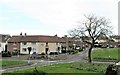
The Loyalist Whitehill Estate. Bangor
This estate is located off the (A21) Newtownards Road.
Image: © Eric Jones
Taken: 17 Apr 2017
0.06 miles
2
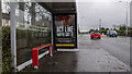
Covid advert, Bangor
Static government Covid awareness advert on a bus shelter at the Newtownards Road, Bangor.
Image: © Rossographer
Taken: 4 Feb 2021
0.11 miles
3
Bus shelter opposite the gate to Bangor Cemetery
The stop is located on the Newtownards Road.
Image: © Eric Jones
Taken: 17 Apr 2017
0.12 miles
4
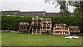
Pallets, Bangor
Stacked pallets on the edge of Castle Park, Bangor. Possibly destined to be burned on an 11th July bonfire.
Image: © Rossographer
Taken: 16 Jun 2020
0.12 miles
5
Bonfire remains, Bangor
The remains of an 11th night bonfire at Castle Park in Bangor. Still smouldering but fenced off.
Image: © Rossographer
Taken: 12 Jul 2020
0.13 miles
6
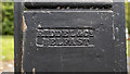
Gates, Bangor
Inscription on the gates seen in Image - this is the maker's name, Riddel & Co. of Belfast.
Image: © Rossographer
Taken: 16 Jun 2020
0.14 miles
7
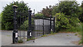
Gates, Bangor
Impressive gates at an entrance to Castle Park from Abbey Hill Drive in Bangor. They were cast by Riddel of Belfast Image and are similar to this example Image
This is almost certainly a relic from when the park was part of the Ward estate Image
Image: © Rossographer
Taken: 16 Jun 2020
0.15 miles
8
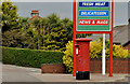
Pillar box, Bangor
EIIR pillar box (BT20 747), at the petrol station/post office, on the corner of the Newtownards Road and Abbey Hill Drive (background).
Image: © Albert Bridge
Taken: 30 May 2012
0.16 miles
9
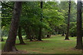
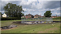
Castle Park, Bangor (2)
In contrast to Castle Park (1) in J5081 this part resembles private parkland and it is not difficult to image aristocratic perambulations at a safe distance from the lower orders. It can be a useful place for fungi hunting during the autumn.
Image: © Albert Bridge
Taken: 21 Jun 2006
0.18 miles
10
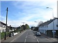
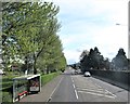
View South along the Newtownards Road at Bangot
Here the Newtownards Road runs through the inner suburbs of Bangor.
Image: © Eric Jones
Taken: 17 Apr 2017
0.18 miles