IMAGES TAKEN NEAR TO
Farnham Park, BANGOR, BT20 3SR
Introduction
This page details the photographs taken nearby to Farnham Park, BT20 3SR by members of the Geograph project.
The Geograph project started in 2005 with the aim of publishing, organising and preserving representative images for every square kilometre of Great Britain, Ireland and the Isle of Man.

There are currently over 7.5m images from over14,400 individuals and you can help contribute to the project by visiting https://www.geograph.org.uk
Image Map
Images are licensed for reuse under creativecommons.org/licenses/by-sa/2.0
Notes
- Clicking on the map will re-center to the selected point.
- The higher the marker number, the further away the image location is from the centre of the postcode.
Image Listing (55 Images Found)
Images are licensed for reuse under creativecommons.org/licenses/by-sa/2.0
Image
Details
Distance
1
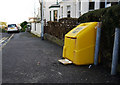
Grit box, Bangor
Grit box on Tennyson Avenue in Bangor.
Image: © Rossographer
Taken: 17 Jan 2010
0.12 miles
2
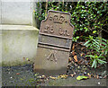
GPO cable marker post, Bangor
The old George V GPO cable marker on Downshire Road in Bangor, previously seen in Image I returned to check if it was still extant - clearly it is but appears to have had a good shove and is now at an angle, possibly when the new gate post behind was installed. I also checked the rear for a foundry name but it appeared blank.
See the site at https://gpo-markers.derektp.co.uk/markers for more information and the locations of these marker posts.
Image: © Rossographer
Taken: 12 Mar 2023
0.12 miles
3
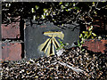
Bench Mark, Bangor
Cut bench mark at the bottom of a wall around a house on the Bryansburn Road in Bangor. Located approximately 20 metres west of the junction with Farnham Road.
See also http://www.geograph.org.uk/search.php?i=11037856 for many other examples I have found.
Image: © Rossographer
Taken: 7 Mar 2010
0.13 miles
4
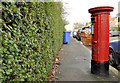
Pillar box, Bangor
See Image The same GR pillar box, at the Bryansburn Road end of Farnham Road, looking in the other direction.
Image: © Albert Bridge
Taken: 1 Dec 2011
0.13 miles
5
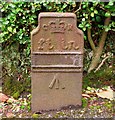
GPO cable marker, Downshire Road, Bangor
Old GPO cable marker on Downshire Road. Would appear to date from sometime between 1910-36 (probably towards the earlier date given when the road was laid out).
This was placed by the General Post Office as a marker plate for their underground Cable network. Originally this would have had a plate giving the distance in feet and inches from post to the underground cable, but this has been removed. Often mistaken as bench marks, the arrow actually signifies that the GPO is a government department.
Any other information that I can add on this is welcomed - a quick search of this site would seem to suggest that examples such as this are rare; another in Lisburn is seen at Image
Image: © Rossographer
Taken: 8 Jul 2008
0.14 miles
6
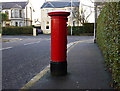
Postbox, Bangor
George V postbox on Farnham Road in Bangor (BT20 407).
Image: © Rossographer
Taken: 17 Jan 2010
0.14 miles
7
Gates, Bangor
A set of gates at a development site on Downshire Road in Bangor. The gates were made by Smith and Pearson of Dublin - see Image I doubt if they'll survive much longer.
Image: © Rossographer
Taken: 12 Mar 2023
0.15 miles
8
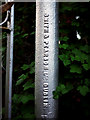
Gates, Bangor
Detail of the gates seen in Image This is the foundry inscription - "Smith & Pearson Ltd., Dublin". Smith and Pearson originated in Ship Street behind Dublin Castle. Thomas Pearson & Co. began manufacturing wire and other steel goods and later amalgamated with Smith. By the early 20th century they were one of the leading structural steel companies in Dublin and had large premises on Liffey Quays in the city. The firm was wound up c1978.
Image: © Rossographer
Taken: 20 Apr 2011
0.16 miles
9
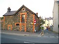
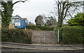
Stone House
This stone house off Princetown Road was renovated over several years. Now looking very well.
Image: © Rossographer
Taken: 24 Oct 2007
0.16 miles
10
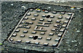
"PLC" fire hydrant cover, Bangor
See Image (April 2011). A similar product, without the “Vina” name, at the Bryansburn Road end of Windsor Avenue. See also Image (December 2011).
Image: © Albert Bridge
Taken: 4 Dec 2012
0.16 miles