IMAGES TAKEN NEAR TO
Martindale, BANGOR, BT20 3QP
Introduction
This page details the photographs taken nearby to Martindale, BT20 3QP by members of the Geograph project.
The Geograph project started in 2005 with the aim of publishing, organising and preserving representative images for every square kilometre of Great Britain, Ireland and the Isle of Man.

There are currently over 7.5m images from over14,400 individuals and you can help contribute to the project by visiting https://www.geograph.org.uk
Image Map
Images are licensed for reuse under creativecommons.org/licenses/by-sa/2.0
Notes
- Clicking on the map will re-center to the selected point.
- The higher the marker number, the further away the image location is from the centre of the postcode.
Image Listing (27 Images Found)
Images are licensed for reuse under creativecommons.org/licenses/by-sa/2.0
Image
Details
Distance
1

Phoenix Gas St Valentine's Day poster, Bangor (February 2015)
The latest Phoenix Gas poster (featuring the Cave Hill and some of Belfast’s best-known buildings) on the Belfast Road, Bangor.
Image: © Albert Bridge
Taken: 10 Feb 2015
0.13 miles
2
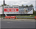
'Legal Name Fraud' advert, Bangor
Billboard advertisement about 'Legal Name Fraud' on the Belfast Road in Bangor. See http://www.bbc.co.uk/news/magazine-36499750 for a good report on these and also the excellent description at Image
The advert on the right is for the local 'Creative Peninsula' event. I can't get any more details on this as the link to the council website - as written on the advert - doesn't contain anything (that might be as I'm writing this after the event finished though).
Image: © Rossographer
Taken: 9 Aug 2016
0.14 miles
3
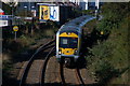
Approaching the Boyne Bridge, Bangor
Much of the Belfast-Bangor railway is in deep cutting. In the last stretch into Bangor the line has the Belfast Road on one side and a rock cut on the other. This is the 09.30 from Lisburn as it approaches the Boyne Bridge under the Brunswick Road. The Belfast Road is on the left.
Image: © Albert Bridge
Taken: 15 Sep 2006
0.14 miles
4
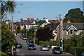
The Brunswick Road, Bangor
The Brunswick Road runs from Abbey Street and the Belfast Road in the general direction of Bangor West. This is the view towards Bangor West.
Image: © Albert Bridge
Taken: 15 Sep 2006
0.14 miles
5
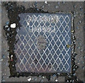
Drain cover, Bangor
Drain cover on the Belfast Road, Bangor, bearing the name "J.F. Brice". A brief search of the records shows a coal importer J.F. Brice living in Farnham Road, Bangor, in 1910; there were also commercial premises named "Auction Mart (J.F. Brice & Son)" at 6 Central Avenue Image It is also possible that this is the same J.F. Brice who donated land off the Donaghadee Road to the borough to be used as a public park - Image Further information welcomed.
Image: © Rossographer
Taken: 12 Oct 2010
0.17 miles
6
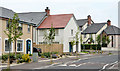
The Shaftesbury Road, Bangor
The Belfast Road end of a private development built, before the recession, on part of what had been the Bangor Dairies site.
Image: © Albert Bridge
Taken: 23 Jul 2013
0.17 miles
7
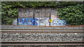
Graffiti, Bangor
Graffiti alongside railway tracks between Bangor and Bangor West stations. The railway milepost shows a distance of 125¼ miles from Dublin Connolly.
Image: © Rossographer
Taken: 27 Nov 2020
0.18 miles
8
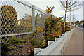
Railway safety measures, Bangor
The railway and the Belfast Road run very close and parallel for a short distance on the outward side of the Boyne Bridge Image The fence stops human trespass. The crash barrier stops runaway vehicles.
Image: © Albert Bridge
Taken: 2 Mar 2010
0.20 miles
9
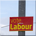
Assembly Election Poster, Bangor
Labour, on the Bryansburn Road, Bangor. (Note - this will be in support of candidates standing for the Northern Ireland Labour Representation Committee such as Image rather than the UK Labour Party which does not field candidates in Northern Ireland).
Image: © Rossographer
Taken: 3 May 2016
0.21 miles
10
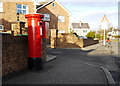
Postbox, Bangor
George V postbox on Grange Road in Bangor (BT20 311).
Image: © Rossographer
Taken: 17 Jan 2010
0.21 miles