IMAGES TAKEN NEAR TO
Belfast Road, BANGOR, BT20 3NN
Introduction
This page details the photographs taken nearby to Belfast Road, BT20 3NN by members of the Geograph project.
The Geograph project started in 2005 with the aim of publishing, organising and preserving representative images for every square kilometre of Great Britain, Ireland and the Isle of Man.

There are currently over 7.5m images from over14,400 individuals and you can help contribute to the project by visiting https://www.geograph.org.uk
Image Map
Images are licensed for reuse under creativecommons.org/licenses/by-sa/2.0
Notes
- Clicking on the map will re-center to the selected point.
- The higher the marker number, the further away the image location is from the centre of the postcode.
Image Listing (17 Images Found)
Images are licensed for reuse under creativecommons.org/licenses/by-sa/2.0
Image
Details
Distance
1
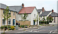
The Shaftesbury Road, Bangor
The Belfast Road end of a private development built, before the recession, on part of what had been the Bangor Dairies site.
Image: © Albert Bridge
Taken: 23 Jul 2013
0.05 miles
2
Vacant house, Bangor
A vacant bungalow on the Belfast Road – boarded up and awaiting redevelopment.
Image: © Albert Bridge
Taken: 2 Mar 2010
0.06 miles
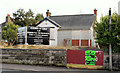
3
Former furniture store, Bangor
This furniture store, at 116 Belfast Road, has been vacant and offered “to let (may sell)” for some time. The agents’ board now has an “agreed” patch. It was once part of “BEL-1” – see also Image (April 2010) and Image (April 1980).
Image: © Albert Bridge
Taken: 23 Jul 2013
0.08 miles
4
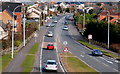
The Belfast Road, Bangor
The view towards the town centre from the ring-road flyover Image
Image: © Albert Bridge
Taken: 2 Mar 2010
0.11 miles
5
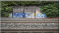
Graffiti, Bangor
Graffiti alongside railway tracks between Bangor and Bangor West stations. The railway milepost shows a distance of 125¼ miles from Dublin Connolly.
Image: © Rossographer
Taken: 27 Nov 2020
0.13 miles
6
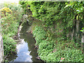
Bryans Burn, Bangor
Bryans Burn as seen from the path near Bangor West Railway Station.
Image: © Rossographer
Taken: 2 May 2008
0.13 miles
7
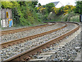
Railway tracks near Bangor
A path runs from the Belfast Road in Bangor to Bangor West Railway Station, from where this picture was taken. The view is towards Bangor.
Image: © Rossographer
Taken: 2 May 2008
0.14 miles
8
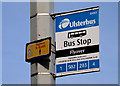
Bus stop, Bangor
Appropriately-named stop on the Bangor side of the ring-road flyover Image
Image: © Albert Bridge
Taken: 2 Mar 2010
0.18 miles
9
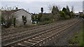
Railway tracks, Bangor
Railway tracks between Bangor and Bangor West stations.
Image: © Rossographer
Taken: 27 Nov 2020
0.19 miles
10
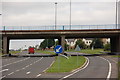
Flyover, Belfast Road, Bangor
This flyover carries the Bangor ring road over the Belfast Road. Most of the traffic to and from Belfast originates from or goes to the ring road and adjacent roads rather than the town centre. This is the view to Belfast.
Image: © Albert Bridge
Taken: 19 Aug 2006
0.21 miles