IMAGES TAKEN NEAR TO
Tudor Park, BANGOR, BT20 3HQ
Introduction
This page details the photographs taken nearby to Tudor Park, BT20 3HQ by members of the Geograph project.
The Geograph project started in 2005 with the aim of publishing, organising and preserving representative images for every square kilometre of Great Britain, Ireland and the Isle of Man.

There are currently over 7.5m images from over14,400 individuals and you can help contribute to the project by visiting https://www.geograph.org.uk
Image Map
Images are licensed for reuse under creativecommons.org/licenses/by-sa/2.0
Notes
- Clicking on the map will re-center to the selected point.
- The higher the marker number, the further away the image location is from the centre of the postcode.
Image Listing (2 Images Found)
Images are licensed for reuse under creativecommons.org/licenses/by-sa/2.0
Image
Details
Distance
1
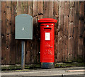
Pillar box, Bangor
GR pillar box, on the Clandeboye Road, between Marquis Avenue and the ring road.
Image: © Albert Bridge
Taken: 4 Feb 2011
0.17 miles
2
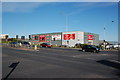
Retail warehouses, Bangor ring road
One of the features of the Bangor ring road is the presence of “out of town” shopping – including retail warehouses. This part of the road where it crosses the Clandeboye Road (middle right) is typical.
Image: © Albert Bridge
Taken: 2 Nov 2006
0.20 miles