IMAGES TAKEN NEAR TO
Brunswick Lane, BANGOR, BT20 3GH
Introduction
This page details the photographs taken nearby to Brunswick Lane, BT20 3GH by members of the Geograph project.
The Geograph project started in 2005 with the aim of publishing, organising and preserving representative images for every square kilometre of Great Britain, Ireland and the Isle of Man.

There are currently over 7.5m images from over14,400 individuals and you can help contribute to the project by visiting https://www.geograph.org.uk
Image Map
Images are licensed for reuse under creativecommons.org/licenses/by-sa/2.0
Notes
- Clicking on the map will re-center to the selected point.
- The higher the marker number, the further away the image location is from the centre of the postcode.
Image Listing (36 Images Found)
Images are licensed for reuse under creativecommons.org/licenses/by-sa/2.0
Image
Details
Distance
1
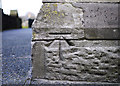
Bench Mark, Bangor
Cut bench mark located on north-western tip of St. Comgalls church on Brunswick Road in Bangor.
See also http://www.geograph.org.uk/search.php?i=11037856 for many other examples I have found.
Image: © Rossographer
Taken: 3 Mar 2010
0.10 miles
2
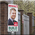
Assembly Election Poster, Bangor
Conal Browne, Social Democratic and Labour Party, at the Brunswick Road, Bangor.
Image: © Rossographer
Taken: 1 May 2016
0.11 miles
3
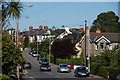
The Brunswick Road, Bangor
The Brunswick Road runs from Abbey Street and the Belfast Road in the general direction of Bangor West. This is the view towards Bangor West.
Image: © Albert Bridge
Taken: 15 Sep 2006
0.13 miles
4
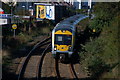
Approaching the Boyne Bridge, Bangor
Much of the Belfast-Bangor railway is in deep cutting. In the last stretch into Bangor the line has the Belfast Road on one side and a rock cut on the other. This is the 09.30 from Lisburn as it approaches the Boyne Bridge under the Brunswick Road. The Belfast Road is on the left.
Image: © Albert Bridge
Taken: 15 Sep 2006
0.13 miles
5
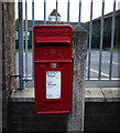
Postbox, Bangor
Post mounted Elizabeth II box on the Brunswick Road in Bangor (BT20 319).
Image: © Rossographer
Taken: 3 Mar 2010
0.13 miles
6
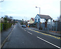
Brunswick Road, Bangor
A pleasant mainly residential area despite its close proximity to the town centre. This is the view towards the junction with Abbey Street/Belfast Road.
Image: © Rossographer
Taken: 20 Jan 2008
0.14 miles
7
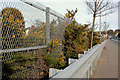
Railway safety measures, Bangor
The railway and the Belfast Road run very close and parallel for a short distance on the outward side of the Boyne Bridge Image The fence stops human trespass. The crash barrier stops runaway vehicles.
Image: © Albert Bridge
Taken: 2 Mar 2010
0.15 miles
8
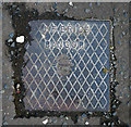
Drain cover, Bangor
Drain cover on the Belfast Road, Bangor, bearing the name "J.F. Brice". A brief search of the records shows a coal importer J.F. Brice living in Farnham Road, Bangor, in 1910; there were also commercial premises named "Auction Mart (J.F. Brice & Son)" at 6 Central Avenue Image It is also possible that this is the same J.F. Brice who donated land off the Donaghadee Road to the borough to be used as a public park - Image Further information welcomed.
Image: © Rossographer
Taken: 12 Oct 2010
0.16 miles
9

Railway signal, Bangor
A three-aspect colour light signal on the up line (to Belfast) beside the Belfast Road.
Image: © Albert Bridge
Taken: 1 Oct 2013
0.16 miles
10
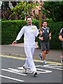
Olympic Torch Relay, Bangor
The torch relay on the Bryansburn Road in Bangor. The torch arrives! A relay runner heads towards Bangor town centre. The man in grey running alongside is an officer from the Metropolitan Police Service. According to the service: "As the host city police force, the Met will be providing a torch security team, who are responsible for the integrity, safety and security of the Olympic and Paralympic Flames and the torchbearer who is holding the Flame. A Torch Security Team will provide the immediate protection to the Flame and the torchbearer throughout the Relays."
Image: © Rossographer
Taken: 3 Jun 2012
0.17 miles