IMAGES TAKEN NEAR TO
Cleland Park North, BANGOR, BT20 3EN
Introduction
This page details the photographs taken nearby to Cleland Park North, BT20 3EN by members of the Geograph project.
The Geograph project started in 2005 with the aim of publishing, organising and preserving representative images for every square kilometre of Great Britain, Ireland and the Isle of Man.

There are currently over 7.5m images from over14,400 individuals and you can help contribute to the project by visiting https://www.geograph.org.uk
Image Map
Images are licensed for reuse under creativecommons.org/licenses/by-sa/2.0
Notes
- Clicking on the map will re-center to the selected point.
- The higher the marker number, the further away the image location is from the centre of the postcode.
Image Listing (7 Images Found)
Images are licensed for reuse under creativecommons.org/licenses/by-sa/2.0
Image
Details
Distance
2
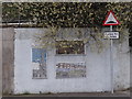
Murals on the corner
Three tiled designs on the wall at the corner of Skipperstone Road and Newtownards Road.
Image: © Ian Paterson
Taken: 9 Apr 2014
0.13 miles
3
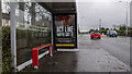
Covid advert, Bangor
Static government Covid awareness advert on a bus shelter at the Newtownards Road, Bangor.
Image: © Rossographer
Taken: 4 Feb 2021
0.15 miles
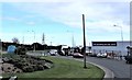
4
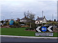
No caption required
This is the Newtownards Road Roundabout. Does exactly what it says on the label! I like the blue navigation buoys.
Image: © Ian Paterson
Taken: 9 Apr 2014
0.17 miles
5
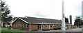
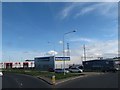
The Original Factory Shop at the Newtownards Road Roundabout, Bangor
Image: © Eric Jones
Taken: 17 Apr 2017
0.22 miles
6
The Original Factory Shop at the Newtownards Road Roundabout
Image: © Eric Jones
Taken: 17 Apr 2017
0.22 miles
7
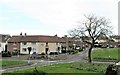
The Loyalist Whitehill Estate. Bangor
This estate is located off the (A21) Newtownards Road.
Image: © Eric Jones
Taken: 17 Apr 2017
0.24 miles