IMAGES TAKEN NEAR TO
Primrose Avenue, BANGOR, BT20 3BA
Introduction
This page details the photographs taken nearby to Primrose Avenue, BT20 3BA by members of the Geograph project.
The Geograph project started in 2005 with the aim of publishing, organising and preserving representative images for every square kilometre of Great Britain, Ireland and the Isle of Man.

There are currently over 7.5m images from over14,400 individuals and you can help contribute to the project by visiting https://www.geograph.org.uk
Image Map
Images are licensed for reuse under creativecommons.org/licenses/by-sa/2.0
Notes
- Clicking on the map will re-center to the selected point.
- The higher the marker number, the further away the image location is from the centre of the postcode.
Image Listing (791 Images Found)
Images are licensed for reuse under creativecommons.org/licenses/by-sa/2.0
Image
Details
Distance
1
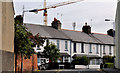
Primrose Avenue, Bangor (1)
A street, between Gray’s Hill and Central Avenue, built over a long number of years between the late 19th and early 20th centuries. This crane Image is in the background. The telecommunications equipment is on the telephone exchange Image Image shows the cast street sign.
Image: © Albert Bridge
Taken: 15 Sep 2011
0.02 miles
2
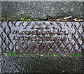
Drain cover, Bangor
Part of a drainage cover located on Primrose Street in Bangor. It is marked "J. Moore and Sons Ltd., Millfield Foundry, Belfast". This is almost certainly the same James Moore seen in Image
Image: © Rossographer
Taken: 12 Mar 2011
0.02 miles
3
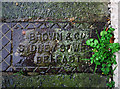
Drain cover, Bangor
Part of a drainage cover located on Primrose Street in Bangor. It is marked "Brown and Co., Sydney Street West, Belfast". See also Image on the same street, showing and Brown and Company cover with the address of Chamberlain Street in Belfast.
Image: © Rossographer
Taken: 12 Mar 2011
0.02 miles
4
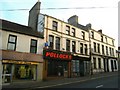
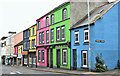
Derelict buildings, Grays Hill
I believe that the terraces on the right are due to be either demolished or renovated. 'Pollocks' has recently closed down - this was a long standing newsagent and tobacconist in Bangor. It gained notoriety among generations of schoolboys for having the finest collection of pornographic magazines in Bangor!
Image: © Rossographer
Taken: 24 Oct 2007
0.03 miles
5
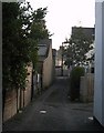
Primrose Lane, Bangor
Primrose Lane is little more than an entry running behind Southwell Road.
Image: © Rossographer
Taken: 11 Feb 2008
0.04 miles
6
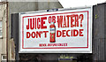
"Drench" poster, Bangor (May 2017)
A poster, at Gray’s Hill, advertising “Drench” flavoured spring water https://drenchjuicyspringwater.com/. I have no connection with the product.
Image: © Albert Bridge
Taken: 25 May 2017
0.04 miles
7

Advert, Bangor
Advert for the "Spend Local" scheme in which everyone aged 18 and over in Northern Ireland can apply for a £100 card to use in shops before the end of November 2021 (later extended to 14th December). There is an application process and the cards cannot be used for online purchases. The scheme, which has cost the Northern Ireland Executive around £145m, is designed to boost local businesses hit hard by the Covid pandemic. See https://www.bbc.co.uk/news/uk-northern-ireland-58682692 for further details.
Image: © Rossographer
Taken: 27 Oct 2021
0.04 miles
8
Derelict buildings, Gray's Hill, Bangor (May 2017)
A scene of utter dereliction hidden behind disguises.
Image: © Albert Bridge
Taken: 25 May 2017
0.04 miles
9
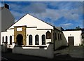
Church of Christ, Bangor
Located on Southwell Road. I can find few details on the building, but the website at http://church-of-christ.org/churches/Northern_Ireland/Down_S.htm gives some information on the church.
Image: © Rossographer
Taken: 3 Aug 2008
0.04 miles
10
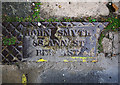
Drain cover, Bangor
Part of a drainage cover located on Primose Street, Bangor. It bears the name of "John Smyth, 88 Ann Street, Belfast". John Smyth was working in Ann Street in the early 1900s - I think that number 88 is now occupied by a bank - see Image
Image: © Rossographer
Taken: 12 Mar 2011
0.04 miles