IMAGES TAKEN NEAR TO
Dufferin Avenue, BANGOR, BT20 3AL

Introduction

This page details the photographs taken nearby to Dufferin Avenue, BT20 3AL by members of the Geograph project.

The Geograph project started in 2005 with the aim of publishing, organising and preserving representative images for every square kilometre of Great Britain, Ireland and the Isle of Man.

There are currently over 7.5m images from over14,400 individuals and you can help contribute to the project by visiting https://www.geograph.org.uk

Image Map


Images are licensed for reuse under creativecommons.org/licenses/by-sa/2.0
Notes
  • Clicking on the map will re-center to the selected point.
  • The higher the marker number, the further away the image location is from the centre of the postcode.

Image Listing (560 Images Found)

Images are licensed for reuse under creativecommons.org/licenses/by-sa/2.0
  • ...
Image
Details
Distance
1
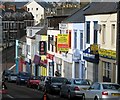
Dufferin Avenue, Bangor
Formerly Catherine Place, this is the oldest section of the road, running from Main Street to Southwell Road, which has existed since around 1833. The present name comes from the 1st Marquess of Dufferin and Ava.
Image: © Rossographer Taken: 2 Mar 2008
0.01 miles
2
Apartments site, Bangor (1)
The view from Dufferin Avenue towards Railwayview Street. Image shows the completed development.
Image: © Albert Bridge Taken: 1 May 2012
0.01 miles
3
Apartments site, Bangor (2)
The site seen from Railwayview Street.
Image: © Albert Bridge Taken: 1 May 2012
0.01 miles
4
Catherine Place, Bangor (2013)
The site, looking towards Dufferin Avenue, still offered for sale.
Image: © Albert Bridge Taken: 23 Jul 2013
0.01 miles
5
Catherine Place apartments, Bangor (September 2015)
27 private-sector apartments under construction on what was formerly a long-term vacant site at Dufferin Avenue. It appears that they will be offered for renting rather than for sale. This photograph appears as a matter of record only. I have no connection with the developer and cannot enter into correspondence.
Image: © Albert Bridge Taken: 26 Sep 2015
0.02 miles
6
Catherine Place apartments, Bangor (November 2017)
The completed development, at the corner of Dufferin Avenue and Railwayview Street. Image (May 2012) shows the vacant site long before work started
Image: © Albert Bridge Taken: 2 Nov 2017
0.02 miles
7
Gully grating, Bangor
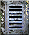
A grating located at the bottom of Railwayview Street in Bangor. It is marked "Millfield Foundry Belfast 1923" and is one of two examples in the street. Notable in that it is a very different design from others commonly seen from the foundry on Belfast streets.
Image: © Rossographer Taken: 20 Apr 2011
0.02 miles
8
Drain cover, bangor
Part of a drainage cover located at the bottom of Railwayview Street in Bangor. It is marked "Bell and Co., Belfast" - see similar at Image and Image Further information on the company is welcomed.
Image: © Rossographer Taken: 20 Apr 2011
0.02 miles
9
Millfield Foundry grating cover, Bangor
See Image An identical Millfield Foundry grating cover, on the other side of Railwayview Street but with the date (1923) partly hidden by the double yellow lines.
Image: © Albert Bridge Taken: 1 Dec 2011
0.04 miles
10
Dufferin Avenue, Bangot
Image: © Eric Jones Taken: 17 Apr 2017
0.04 miles
  • ...