IMAGES TAKEN NEAR TO
King Street, BANGOR, BT20 3AH
Introduction
This page details the photographs taken nearby to King Street, BT20 3AH by members of the Geograph project.
The Geograph project started in 2005 with the aim of publishing, organising and preserving representative images for every square kilometre of Great Britain, Ireland and the Isle of Man.

There are currently over 7.5m images from over14,400 individuals and you can help contribute to the project by visiting https://www.geograph.org.uk
Image Map
Images are licensed for reuse under creativecommons.org/licenses/by-sa/2.0
Notes
- Clicking on the map will re-center to the selected point.
- The higher the marker number, the further away the image location is from the centre of the postcode.
Image Listing (990 Images Found)
Images are licensed for reuse under creativecommons.org/licenses/by-sa/2.0
Image
Details
Distance
1
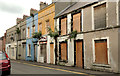
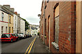
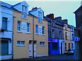
King Street, Bangor (4)
Some of the properties (almost all of which are vacant and boarded-up) on the northern side of the street. The Vennel is out of picture to the right. Their numbers are no longer visible.
Image: © Albert Bridge
Taken: 28 Aug 2012
0.01 miles
2
King Street, Bangor (3)
King Street at The Vennel Image (right - leading to Queen’s Parade Image). Image shows the same part of the street in August 2008.
Image: © Albert Bridge
Taken: 28 Aug 2012
0.01 miles
3
King Street, Bangor (November 2014)
The site location plan, for the planning application (see the shared description, below), confirms that this row, at the corner of The Vennel (right) is included in the scheme for the proposed redevelopment of Queen’s Parade. Previously seen in Image (August 2012).
Image: © Albert Bridge
Taken: 4 Nov 2014
0.01 miles
4
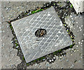
Macnaughton access cover, Bangor (November 2014)
An access cover, at King Street, bearing the name N Macnaughton & Sons Ltd. For other products from this company and a short history see http://www.geograph.org.uk/search.php?i=52100595
Image: © Albert Bridge
Taken: 4 Nov 2014
0.01 miles
5
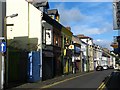
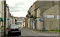
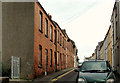
King Street, Bangor
Street running from Main Street to Southwell Road. Laid out around 1833 it was formerly known as 'Souter's Row' ('souter' means shoemaker - see Image) and, around 1880, as West Street. The current name seems to have been in existence since around 1910, probably a result of King Edward VII visiting Bangor. It is now a mix of residential dwellings, shops, a cafe, public house, bookmakers, take-away and restaurant.
Image: © Rossographer
Taken: 3 Aug 2008
0.01 miles
6
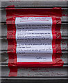
Closure notice, Bangor
Like so many other premises, Simple Simon home bakery in King Street, Bangor, was forced to close due to the Covid-19 Coronavirus pandemic. This hand written note explains and I shall have to learn to bake my own scones.
Image: © Rossographer
Taken: 25 Mar 2020
0.02 miles
7
King Street, Bangor (2)
Nos 20-34 (right - looking towards the Southwell Road) built circa 1912 and now all vacant pending redevelopment. Image shows a similar view in June 2010.
Image: © Albert Bridge
Taken: 28 Aug 2012
0.02 miles
8
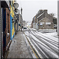
King Street, Bangor
There was a brief snowfall in Bangor on 13th February 2021 - being very cold already it rapidly accumulated on the ground but the temperature rose quickly and all had melted again by the evening. This is King Street in the town.
Image: © Rossographer
Taken: 13 Feb 2021
0.02 miles
9
Apartments on King Street
I don't like the flats but am impressed by the owner's local history.
Souter's Row (meaning Shoemakers) was the former name of King Street.
Image: © Rossographer
Taken: 7 Oct 2007
0.02 miles
10
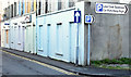
King Street, Bangor (1)
Nos 20-34 (left - at the Southwell Road end) built circa 1912 and now all vacant pending redevelopment.
Image: © Albert Bridge
Taken: 28 Aug 2012
0.02 miles