IMAGES TAKEN NEAR TO
Balmoral Road, BANGOR, BT19 7XA
Introduction
This page details the photographs taken nearby to Balmoral Road, BT19 7XA by members of the Geograph project.
The Geograph project started in 2005 with the aim of publishing, organising and preserving representative images for every square kilometre of Great Britain, Ireland and the Isle of Man.

There are currently over 7.5m images from over14,400 individuals and you can help contribute to the project by visiting https://www.geograph.org.uk
Image Map
Images are licensed for reuse under creativecommons.org/licenses/by-sa/2.0
Notes
- Clicking on the map will re-center to the selected point.
- The higher the marker number, the further away the image location is from the centre of the postcode.
Image Listing (2 Images Found)
Images are licensed for reuse under creativecommons.org/licenses/by-sa/2.0
Image
Details
Distance
1
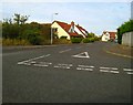
Cayman Drive
Off Primacy Road. Fairly bland housing like almost everything else around.
Image: © Rossographer
Taken: 14 Oct 2007
0.20 miles
2

Primacy Road
Primacy was once a small settlement on the outskirts of Bangor. It was swallowed into part of Bangor long ago - these houses are much older than others around them and give a glimpse of what the area was once like.
Image: © Rossographer
Taken: 14 Oct 2007
0.21 miles