IMAGES TAKEN NEAR TO
Cotton Road, BANGOR, BT19 7QH
Introduction
This page details the photographs taken nearby to Cotton Road, BT19 7QH by members of the Geograph project.
The Geograph project started in 2005 with the aim of publishing, organising and preserving representative images for every square kilometre of Great Britain, Ireland and the Isle of Man.

There are currently over 7.5m images from over14,400 individuals and you can help contribute to the project by visiting https://www.geograph.org.uk
Image Map
Images are licensed for reuse under creativecommons.org/licenses/by-sa/2.0
Notes
- Clicking on the map will re-center to the selected point.
- The higher the marker number, the further away the image location is from the centre of the postcode.
Image Listing (4 Images Found)
Images are licensed for reuse under creativecommons.org/licenses/by-sa/2.0
Image
Details
Distance
1
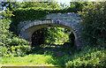
Old railway bridge near Donaghadee
The line of the old Belfast & County Down Railway (BCDR) which went under this bridge at Cottown (now disused). This was the line from Donaghadee to Newtownards.
Image: © Rossographer
Taken: 14 Jul 2019
0.12 miles
2
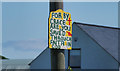
Religious message near Bangor
Religious message on the Cottown Road between Six Road Ends and Donaghadee.
Image: © Rossographer
Taken: 14 Jul 2019
0.17 miles
3
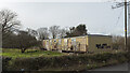
Former school near Bangor
The former Cotton Primary School near Bangor. Long vacated and vandalised, I believe that the site will soon be cleared.
Image: © Rossographer
Taken: 12 Mar 2022
0.19 miles
4

Postbox near Bangor
Post mounted EIIR postbox (BT19 101) on the Corner of Bailie Road/Donaghadee Road at Cotton, near Bangor.
Image: © Rossographer
Taken: 12 Mar 2022
0.20 miles