IMAGES TAKEN NEAR TO
Ballycrochan Road, BANGOR, BT19 7PY
Introduction
This page details the photographs taken nearby to Ballycrochan Road, BT19 7PY by members of the Geograph project.
The Geograph project started in 2005 with the aim of publishing, organising and preserving representative images for every square kilometre of Great Britain, Ireland and the Isle of Man.

There are currently over 7.5m images from over14,400 individuals and you can help contribute to the project by visiting https://www.geograph.org.uk
Image Map
Images are licensed for reuse under creativecommons.org/licenses/by-sa/2.0
Notes
- Clicking on the map will re-center to the selected point.
- The higher the marker number, the further away the image location is from the centre of the postcode.
Image Listing (3 Images Found)
Images are licensed for reuse under creativecommons.org/licenses/by-sa/2.0
Image
Details
Distance
1
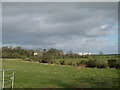
The Ballycrochan Road near Bangor
The last part of the rural road before it meets the edge of Bangor at Ballycrochan.
Image: © Rossographer
Taken: 14 Apr 2020
0.19 miles
2
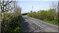
Humped Back Bridge, Ballycrochan Road
This bridge (road to the right) was built to carry the road over the railway line that ran to Donaghadee. The line has long since gone but the bridge remains. The lane to the left seems to be used for storage by a local farmer.
As the development of housing spreads to the land right of the road I feel that the road may be levelled out in the near future.
Image: © Rossographer
Taken: 7 Oct 2007
0.20 miles