IMAGES TAKEN NEAR TO
Bloomfield Road South, BANGOR, BT19 7PN
Introduction
This page details the photographs taken nearby to Bloomfield Road South, BT19 7PN by members of the Geograph project.
The Geograph project started in 2005 with the aim of publishing, organising and preserving representative images for every square kilometre of Great Britain, Ireland and the Isle of Man.

There are currently over 7.5m images from over14,400 individuals and you can help contribute to the project by visiting https://www.geograph.org.uk
Image Map
Images are licensed for reuse under creativecommons.org/licenses/by-sa/2.0
Notes
- Clicking on the map will re-center to the selected point.
- The higher the marker number, the further away the image location is from the centre of the postcode.
Image Listing (3 Images Found)
Images are licensed for reuse under creativecommons.org/licenses/by-sa/2.0
Image
Details
Distance
1
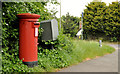
Pillar box and drop box, Bangor
Drop box and EIIR pillar box (BT19 6) at the corner of the Willowbrook Road and the Balloo Road (background).
Image: © Albert Bridge
Taken: 2 Jun 2012
0.21 miles
2
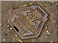
Brickhouse stop valve cover, Bangor
A Brickhouse “Vulcan” Image stop valve cover, on the Willowbrook Road, opposite the Primacy Road.
Image: © Albert Bridge
Taken: 2 Jun 2012
0.23 miles
3
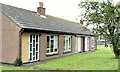
Vacant social housing, Bangor (July 2015)
It appears that these properties (of a type once known as “pensioners’ bungalows”), close to Skipperstone Avenue, are owned by a “provident trust” and are three of many similar ones vacant locally without a published explanation about their future. This photograph appears as a matter of neutral record only. I have no connection with the trust or any political party. See also Image
Image: © Albert Bridge
Taken: 21 Jul 2015
0.25 miles