IMAGES TAKEN NEAR TO
Bells Hill Road, BANGOR, BT19 7PF
Introduction
This page details the photographs taken nearby to Bells Hill Road, BT19 7PF by members of the Geograph project.
The Geograph project started in 2005 with the aim of publishing, organising and preserving representative images for every square kilometre of Great Britain, Ireland and the Isle of Man.

There are currently over 7.5m images from over14,400 individuals and you can help contribute to the project by visiting https://www.geograph.org.uk
Image Map
Images are licensed for reuse under creativecommons.org/licenses/by-sa/2.0
Notes
- Clicking on the map will re-center to the selected point.
- The higher the marker number, the further away the image location is from the centre of the postcode.
Image Listing (14 Images Found)
Images are licensed for reuse under creativecommons.org/licenses/by-sa/2.0
Image
Details
Distance
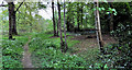
1
Balloo Wood, Bangor (1)
There are several entrances. This one is at Balloo Avenue.
Image: © Albert Bridge
Taken: 3 May 2011
0.01 miles
2
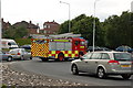
Newtownards Road roundabout, Bangor
The Newtownards Road roundabout is one of five on the Bangor ring road. It is also the busiest. Just as I was returning my camera to its bag I heard the distinctive “nee-naw” from the nearby fire station. This is the result. Note: part of the roundabout is in J5080.
Image: © Albert Bridge
Taken: 29 Jun 2006
0.07 miles
3
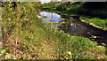
Balloo Wood, Bangor (3)
A pond, at the southern end, looking very low after the long dry spell.
Image: © Albert Bridge
Taken: 3 May 2011
0.08 miles
4
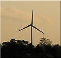
Wind turbine, Bangor
The wind turbine in Balloo Wood - see Image - is clearly visible from many vantage points in Bangor. This picture was taken from Ward Park.
Image: © Rossographer
Taken: 24 Oct 2008
0.09 miles
5
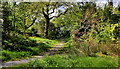
Balloo Wood, Bangor (4)
A path through the northern side of the wood.
Image: © Albert Bridge
Taken: 3 May 2011
0.09 miles
6
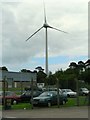
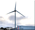
Wind turbine, Bangor
The local council have installed this rather large wind turbine to power their new waste management facility. It is situated in Balloo Wood. The turbine stands 54m high from base to hub, with blades that are 38m in diameter and 19m long; it has an electricity output of 850KW. When this picture was taken it was not yet operational.
Image: © Rossographer
Taken: 7 Jul 2008
0.09 miles
7
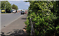
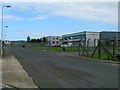
Balloo Avenue, Bangor
Part of a large commercial area, built on flat ground, to the south of the ring road. Balloo Way is at bottom right.
Image: © Albert Bridge
Taken: 3 May 2011
0.11 miles
8
Balloo Wood, Bangor (2)
The southern part of the wood.
Image: © Albert Bridge
Taken: 3 May 2011
0.11 miles
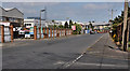
9
Balloo Way, Bangor
Rather nondescript street in the centre of Balloo Industrial Estate, Bangor.
Image: © Rossographer
Taken: 7 Jul 2008
0.11 miles
10
Wind turbine, Bangor (3)
See Image and Image The turbine is impressive when seen from below or from a distance. Despite a height of 55 metres and a blade length of 24 metres, it looks a bit scrawny when seen over the rooftops of the local buildings – in this case from Balloo Drive. Image shows the sensors.
Image: © Albert Bridge
Taken: 26 Nov 2012
0.13 miles