IMAGES TAKEN NEAR TO
Old Ballycrochan Road, BANGOR, BT19 7NZ
Introduction
This page details the photographs taken nearby to Old Ballycrochan Road, BT19 7NZ by members of the Geograph project.
The Geograph project started in 2005 with the aim of publishing, organising and preserving representative images for every square kilometre of Great Britain, Ireland and the Isle of Man.

There are currently over 7.5m images from over14,400 individuals and you can help contribute to the project by visiting https://www.geograph.org.uk
Image Map
Images are licensed for reuse under creativecommons.org/licenses/by-sa/2.0
Notes
- Clicking on the map will re-center to the selected point.
- The higher the marker number, the further away the image location is from the centre of the postcode.
Image Listing (16 Images Found)
Images are licensed for reuse under creativecommons.org/licenses/by-sa/2.0
Image
Details
Distance
1
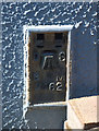
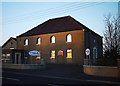
Flush Bracket, Ballygrainey
Flush bracket located on the bottom left hand corner of the former Ballygrainey Post Office (now a private house - see Image).
The number on the bracket is OSBM 3462.
The mark is 29.53 metres above MSL.
A flush bracket is a type of bench mark set onto the face of a building. See also http://www.geograph.org.uk/search.php?i=11037856 for many other examples I have found.
Image: © Rossographer
Taken: 21 Jul 2010
0.02 miles
2
Flush Bracket, Ballygrainey
Flush bracket located on the bottom left hand corner of the former Ballygrainey Post Office (now a dog grooming parlour - see Image).
The number on the bracket is OSBM 3462.
The mark is 29.53 metres above MSL.
A flush bracket is a type of bench mark set onto the face of a building. See also http://www.geograph.org.uk/search.php?i=11037856 for many other examples I have found.
Image: © Rossographer
Taken: 14 Apr 2020
0.02 miles
3
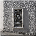
Bench Mark, Six Road Ends
Cut bench mark on the southern entrance to Ballygrainey Presbyterian Church Image & Image at Six Road Ends.
The mark is 34.09 metres above MSL.
See also http://www.geograph.org.uk/search.php?i=11037856 for many other examples I have found.
Image: © Rossographer
Taken: 11 Apr 2010
0.03 miles
4
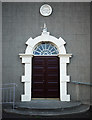
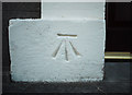
Entrance door, Ballygrainey Presbyterian Church
Southern entrance to Image Note the plaque above the door:
"Erected Anno Domini
Bethel 1837".
Note also the bench mark on the bottom left of the entrance - Image
Image: © Rossographer
Taken: 11 Apr 2010
0.03 miles
5
Ballygrainey Presbyterian Church
Ballygrainey Presbyterian Church, located at the Six Road Ends near Bangor. See http://www.ballygraineychurch.org/ for further information. The building dates from 1837.
Image: © Rossographer
Taken: 11 Apr 2010
0.04 miles
6

Coronavirus message, Six Road Ends
Taken during the Coronavirus pandemic, a message of support to NHS and essential works on an Orange Hall at Ballygrainey (Six Road Ends) near Bangor.
Image: © Rossographer
Taken: 25 Apr 2020
0.04 miles
7
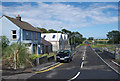
The Ballycrochan Road, Ballygrainey
Now known as the 'Old' Ballycrochan Road after the realignment of the Six Road Ends. This is the view towards Donaghadee. The blue building on the left is the former Ballygrainey Post Office - now a private house. There is a flush bracket on the bottom right of the house - see Image
Image: © Rossographer
Taken: 21 Jul 2010
0.04 miles
8
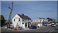
Shop at the Six Road Ends near Bangor
Nash's stores at Six Road Ends near Bangor. Taken during the Coronavirus pandemic, the shop has remained open and is doing a brisk trade. The former Ballygrainey Post Office seen on the left in Image has been redeveloped into a dog grooming parlour.
Image: © Rossographer
Taken: 14 Apr 2020
0.04 miles
9
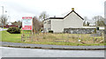
Development site at the Six Road Ends (February 2015)
A site, beside Ballygrainey Orange hall, offered for sale and described on the agent’s board as having planning permission for four semis and one detached house. It’s much bigger than it appears here. This photograph appears as a matter of record only. I have no connection with any of the parties involved in the sale
Image: © Albert Bridge
Taken: 25 Feb 2015
0.05 miles
10

Six Road Ends
The roundabout which has replaced the former network of junctions at this well known location.
Image: © Robert Ashby
Taken: 10 Mar 2016
0.07 miles