IMAGES TAKEN NEAR TO
Andrews Shorefield, BANGOR, BT19 6LJ
Introduction
This page details the photographs taken nearby to Andrews Shorefield, BT19 6LJ by members of the Geograph project.
The Geograph project started in 2005 with the aim of publishing, organising and preserving representative images for every square kilometre of Great Britain, Ireland and the Isle of Man.

There are currently over 7.5m images from over14,400 individuals and you can help contribute to the project by visiting https://www.geograph.org.uk
Image Map
Images are licensed for reuse under creativecommons.org/licenses/by-sa/2.0
Notes
- Clicking on the map will re-center to the selected point.
- The higher the marker number, the further away the image location is from the centre of the postcode.
Image Listing (18 Images Found)
Images are licensed for reuse under creativecommons.org/licenses/by-sa/2.0
Image
Details
Distance
1
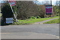
Houses for sale
Lots of development going on alongside the A2 in this area near Groomsport.
Image: © Robert Ashby
Taken: 30 Mar 2016
0.09 miles
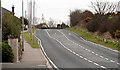
2
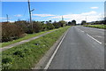
Near Groomsport
The A2 heading towards Donaghadee.
Image: © Robert Ashby
Taken: 30 Mar 2016
0.10 miles
3
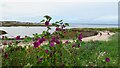
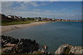
Mary's Bay, Groomsport and Cranesbill flowers
Image: © Colin Park
Taken: 11 Sep 2023
0.13 miles
4
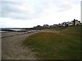
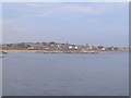
The beach at Groomsport
Groomsport has a small though pleasant sandy beach. Up until a few years ago this was bordered by a caravan site that brought tourists (or, more accurately, residents of the Shankill Road in Belfast) to the village for the summer months. This was recently removed and replaced with the 'Cove Bay' housing development, seen to the right.
Image: © Rossographer
Taken: 24 Nov 2007
0.13 miles

8
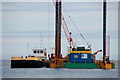
Jack-up rig off Groomsport
See Image The “Needles”, with her cargo of stone, has made fast to the jack-up rig. The rig was located to the east of Groomsport.
Image: © Albert Bridge
Taken: 22 Aug 2006
0.14 miles
9
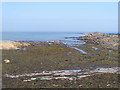
Cove Bay, Groomsport
Much of the shore from Groomsport to beyond Donaghadee is low and rocky. Cove Bay at Groomsport has a small sandy beach composed of fairly sharp sand rather than the smooth variety beloved of builders of sand castles. It is still a place where grandparents take their grandchildren and remind them of what they did 50 years ago. Taken from the Long Rock looking towards Groomsport.
Image: © Albert Bridge
Taken: 24 Jul 2006
0.14 miles
10
The Donaghadee Road, Groomsport
The Donaghadee Road starts at the eastern end of Main Street Image and continues to beyond Orlock where it becomes the Warren Road, Donaghadee. This is the section just beyond the end of the bypass Image
Image: © Albert Bridge
Taken: 9 Apr 2010
0.15 miles