IMAGES TAKEN NEAR TO
Main Street, BANGOR, BT19 6JR
Introduction
This page details the photographs taken nearby to Main Street, BT19 6JR by members of the Geograph project.
The Geograph project started in 2005 with the aim of publishing, organising and preserving representative images for every square kilometre of Great Britain, Ireland and the Isle of Man.

There are currently over 7.5m images from over14,400 individuals and you can help contribute to the project by visiting https://www.geograph.org.uk
Image Map
Images are licensed for reuse under creativecommons.org/licenses/by-sa/2.0
Notes
- Clicking on the map will re-center to the selected point.
- The higher the marker number, the further away the image location is from the centre of the postcode.
Image Listing (131 Images Found)
Images are licensed for reuse under creativecommons.org/licenses/by-sa/2.0
Image
Details
Distance
2
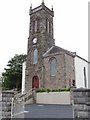
The Tower of Groomsport Presbyterian Church
Information Image
Image: © HENRY CLARK
Taken: 12 Jun 2009
0.01 miles
4
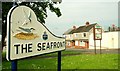
Sign, Groomsport
Recently erected sign at the Harbour Road. Another gem from North Down Borough Council. See Image for a similar one.
Image: © Albert Bridge
Taken: 24 Jul 2008
0.02 miles
5
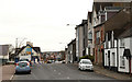
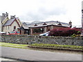
Main Street, Groomsport
Main Street, Groomsport looking towards Donaghadee. Mainly residential with a few shops including a small “Spar” with a mini Post Office. The “Groomsport Inn” Image is at middle left.
Image: © Albert Bridge
Taken: 9 Apr 2010
0.02 miles
6
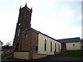
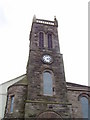
Groomsport Presbyterian Church
Founded 1841 and opened in 1843. See http://www.presbyterianireland.org/congregations/groomsport.html for more info.
Image: © Rossographer
Taken: 24 Nov 2007
0.02 miles
8

Bus, Groomsport
An Ulsterbus Wright Solar-bodied Scania (2463 HXI 463), not in service, at the Main Street (Donaghadee Road on the Google map) stop.
Image: © Albert Bridge
Taken: 25 Apr 2013
0.03 miles
10
![Deserted Groomsport Harbour [2]](https://s3.geograph.org.uk/photos/62/02/620219_b879dad4_120x120.jpg)
Deserted Groomsport Harbour [2]
Another view of the empty harbour, this time looking towards the village.
Image: © Rossographer
Taken: 24 Nov 2007
0.04 miles