IMAGES TAKEN NEAR TO
The Meadow, BANGOR, BT19 6JH
Introduction
This page details the photographs taken nearby to The Meadow, BT19 6JH by members of the Geograph project.
The Geograph project started in 2005 with the aim of publishing, organising and preserving representative images for every square kilometre of Great Britain, Ireland and the Isle of Man.

There are currently over 7.5m images from over14,400 individuals and you can help contribute to the project by visiting https://www.geograph.org.uk
Image Map
Images are licensed for reuse under creativecommons.org/licenses/by-sa/2.0
Notes
- Clicking on the map will re-center to the selected point.
- The higher the marker number, the further away the image location is from the centre of the postcode.
Image Listing (77 Images Found)
Images are licensed for reuse under creativecommons.org/licenses/by-sa/2.0
Image
Details
Distance
1
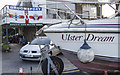
Boat and flag, Groomsport
The motorboat 'Ulster Dream' and, behind on a house, a flag celebrating the Northern Ireland team.
Image: © Rossographer
Taken: 28 May 2016
0.12 miles
2
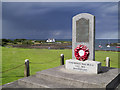
Schomberg Memorial, Groomsport
Another view of the Schomberg Memorial in Groomsport. The monument commemorates the 13th August 1689, when the English Fleet with Frederick Duke of Schomberg & an army of 10,000 men came ashore in Groomsport. Schomberg was later to die at the battle of the Boyne. See Image for the full inscription.
Image: © Rossographer
Taken: 9 Aug 2014
0.13 miles
3
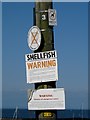
Signs, Groomsport
Various signs on a telegraph pole at 'The Point', Groomsport.
Image: © Rossographer
Taken: 18 May 2008
0.13 miles
4
![Schomberg Memorial, Groomsport [2]](https://s2.geograph.org.uk/photos/59/80/598002_83bfdba8_120x120.jpg)
Schomberg Memorial, Groomsport [2]
Detail of Image
Image: © Rossographer
Taken: 29 Oct 2007
0.14 miles
5
![Schomberg Memorial, Groomsport [1]](https://s0.geograph.org.uk/photos/59/80/598000_d0ef7608_120x120.jpg)
Schomberg Memorial, Groomsport [1]
Commemorating the 13th August 1689, when the English Fleet with Frederick Duke of Schomberg & an army of 10,000 men came ashore in Groomsport. Schomberg was later to die at the battle of the Boyne.
Image: © Rossographer
Taken: 29 Oct 2007
0.14 miles
6
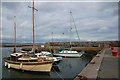
Groomsport harbour
A view of Groomsport harbour – looking towards the pier Image
Image: © Albert Bridge
Taken: 26 Jul 2007
0.14 miles
7

Bollards, Groomsport harbour
See Image The bollards are marked around the outside top “J. Graham, 1902 - Contractor”. Also marked "J. Moore & Sons Ltd - Iron Founders" in a smaller circle near the centre.
Image: © Albert Bridge
Taken: 26 Jul 2007
0.14 miles
9
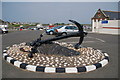
The Groomsport anchor
The harbour at Groomsport is used almost exclusively by small pleasure craft. There was a lifeboat station from 1858 to 1920. The old lifeboathouse (top right) is still a boathouse (now under municipal ownership). The origin of the anchor is not known. It was brought ashore by a local fishing boat in the mid-60’s.
Image: © Albert Bridge
Taken: 7 Jun 2006
0.14 miles
10
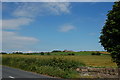
Bangor Road, Groomsport (3)
Just after the Groomsport Road roundabout at the eastern end of the Bangor ring road there is just under a mile of greenery before reaching Groomsport. This is the view in the general direction of Ballymacormick and Belfast Lough.
Image: © Albert Bridge
Taken: 25 Jun 2006
0.14 miles