IMAGES TAKEN NEAR TO
Moorings Court, BANGOR, BT19 6JB
Introduction
This page details the photographs taken nearby to Moorings Court, BT19 6JB by members of the Geograph project.
The Geograph project started in 2005 with the aim of publishing, organising and preserving representative images for every square kilometre of Great Britain, Ireland and the Isle of Man.

There are currently over 7.5m images from over14,400 individuals and you can help contribute to the project by visiting https://www.geograph.org.uk
Image Map
Images are licensed for reuse under creativecommons.org/licenses/by-sa/2.0
Notes
- Clicking on the map will re-center to the selected point.
- The higher the marker number, the further away the image location is from the centre of the postcode.
Image Listing (133 Images Found)
Images are licensed for reuse under creativecommons.org/licenses/by-sa/2.0
Image
Details
Distance
1
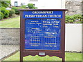
Groomsport Presbyterian Church
Information Board Image
Image: © HENRY CLARK
Taken: 12 Jun 2009
0.03 miles
2
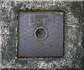
Drain cover, Groomsport
Drain cover located on the pavement on Main Street in Groomsport. It is marked "J. Riddel and Son Ltd., Belfast". The company John Riddel and Son was founded in 1803 and continues to trade today - see http://www.riddel.co.uk/ .
Image: © Rossographer
Taken: 4 Jun 2011
0.03 miles
3

Tennis courts in Main Street, Groomsport
Image: © Eric Jones
Taken: 28 Mar 2017
0.03 miles
4
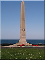
Groomsport War Memorial
War Memorial overlooking the shore between the Main Street and the harbour.
Image: © Rossographer
Taken: 17 Mar 2008
0.03 miles
5

Bus, Groomsport
An Ulsterbus Wright Solar-bodied Scania (2463 HXI 463), not in service, at the Main Street (Donaghadee Road on the Google map) stop.
Image: © Albert Bridge
Taken: 25 Apr 2013
0.04 miles
6

Groomsport War Memorial
Groomsport War Memorial http://www.geograph.org.uk/of/groomsport+war+memorial+J5383 which is sited between Main Street and the shore in the village, although in this view I have isolated it against the sky.
Image: © Rossographer
Taken: 9 Aug 2014
0.04 miles
7
War Memorial, Groomsport
This memorial was erected in 1924.
http://www.groomsportwarmemorial.co.uk/?page_id=16
Image: © Eric Jones
Taken: 28 Mar 2017
0.04 miles
8
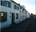
'The Hill', Groomsport
A neat terrace showing a wide variety of building styles on a rise above the Main Street in Groomsport.
Image: © Rossographer
Taken: 17 Mar 2008
0.05 miles
9

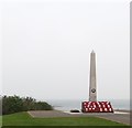
Groomsport War Memorial
Detail of the Groomsport War Memorial Image
In common with many memorials, it lists the dates of the Great War as 1914-1919. The war did not officially end until the Treaty of Versailles was signed in June 1919.
Image: © Rossographer
Taken: 18 Aug 2010
0.05 miles