IMAGES TAKEN NEAR TO
The Briggs, BANGOR, BT19 6HY
Introduction
This page details the photographs taken nearby to The Briggs, BT19 6HY by members of the Geograph project.
The Geograph project started in 2005 with the aim of publishing, organising and preserving representative images for every square kilometre of Great Britain, Ireland and the Isle of Man.

There are currently over 7.5m images from over14,400 individuals and you can help contribute to the project by visiting https://www.geograph.org.uk
Image Map
Images are licensed for reuse under creativecommons.org/licenses/by-sa/2.0
Notes
- Clicking on the map will re-center to the selected point.
- The higher the marker number, the further away the image location is from the centre of the postcode.
Image Listing (133 Images Found)
Images are licensed for reuse under creativecommons.org/licenses/by-sa/2.0
Image
Details
Distance
1
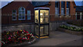
Telephone Call Box, Groompsort
BT KX100 telephone box at Main Street, Groomsport. Phone and interior light both still in working order.
Image: © Rossographer
Taken: 21 Jul 2021
0.02 miles
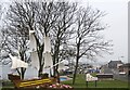
2
Springwell Drive, Groomsport
At the top of the hill is the Groomsport Primary School.
Image: © Eric Jones
Taken: 28 Mar 2017
0.03 miles
3
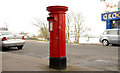
Pillar box, Groomsport
EIIR pillar box in Main Street, close to the former post office (closed in the last round of closures). Some postal facilities are still available in the nearby “Spar”.
Image: © Albert Bridge
Taken: 8 Feb 2011
0.03 miles
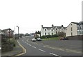
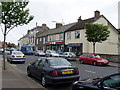
4
The Main Street in Groomsport
At the junction with Harbour Road
Image: © HENRY CLARK
Taken: 12 Jun 2009
0.04 miles
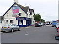
5
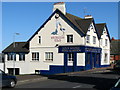
The 'Groomsport Inn'
Until recently named the 'Lock and Quay', this is the only public house in the village. Taken on St Patrick's Day, this was unusually quiet.
Image: © Rossographer
Taken: 17 Mar 2008
0.04 miles
6
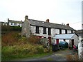
Old buildings, Groomsport
These buildings sit just behind those fronting onto the Main Street.
Image: © Rossographer
Taken: 24 Nov 2007
0.04 miles
7

Bench mark, Groomsport
Cut bench mark at the bottom of a wall/post on Main Street in Groomsport - see Image - the mark is at the bottom of the stone post.
The mark is 7.86 metres above MSL.
See also http://www.geograph.org.uk/search.php?i=11037856 for many other examples I have found.
Image: © Rossographer
Taken: 21 Mar 2010
0.05 miles
10
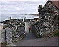
Footpath, Groomsport
Short path leading from Main Street to the shore at Groomsport. There is a bench mark on the right hand post - see Image
Image: © Rossographer
Taken: 21 Mar 2010
0.05 miles