IMAGES TAKEN NEAR TO
Sherwood Park, BANGOR, BT19 6DN
Introduction
This page details the photographs taken nearby to Sherwood Park, BT19 6DN by members of the Geograph project.
The Geograph project started in 2005 with the aim of publishing, organising and preserving representative images for every square kilometre of Great Britain, Ireland and the Isle of Man.

There are currently over 7.5m images from over14,400 individuals and you can help contribute to the project by visiting https://www.geograph.org.uk
Image Map
Images are licensed for reuse under creativecommons.org/licenses/by-sa/2.0
Notes
- Clicking on the map will re-center to the selected point.
- The higher the marker number, the further away the image location is from the centre of the postcode.
Image Listing (6 Images Found)
Images are licensed for reuse under creativecommons.org/licenses/by-sa/2.0
Image
Details
Distance
1
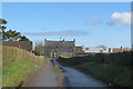
Near Bangor
Derelict farmhouse just off the High Bangor Road.
Image: © Robert Ashby
Taken: 10 Mar 2016
0.07 miles
2
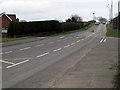
Donaghadee Road, Bangor
Looking towards Donaghadee from the eastern edge of Bangor.
Image: © Rossographer
Taken: 22 Mar 2008
0.12 miles
3
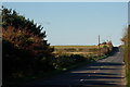
The High Road from Donaghadee
See Image This is the view towards Bangor, just under a mile from the roundabout on the ring road.
Image: © Albert Bridge
Taken: 2 Nov 2006
0.14 miles
4
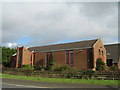
Ballycrochan Baptist Church
Ballycrochan Baptist Church opened on the 8th January 1983. It is situated on Ballycrochan Road near its junction with Donaghadee Road.
Image: © Sue Adair
Taken: 26 Feb 2008
0.16 miles
5
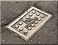
Fire hydrant cover, Bangor (October 2014)
An anonymous fire hydrant cover at the Donaghadee Road end of Kilmaine Road.
Image: © Albert Bridge
Taken: 2 Oct 2014
0.21 miles
6
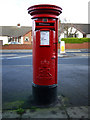
Postbox, Bangor
Elizabeth II postbox on the Donaghadee Road in Bangor (BT19 539).
Image: © Rossographer
Taken: 13 Dec 2009
0.23 miles