IMAGES TAKEN NEAR TO
Killaire Wood Lane, BANGOR, BT19 1ZW
Introduction
This page details the photographs taken nearby to Killaire Wood Lane, BT19 1ZW by members of the Geograph project.
The Geograph project started in 2005 with the aim of publishing, organising and preserving representative images for every square kilometre of Great Britain, Ireland and the Isle of Man.

There are currently over 7.5m images from over14,400 individuals and you can help contribute to the project by visiting https://www.geograph.org.uk
Image Map
Images are licensed for reuse under creativecommons.org/licenses/by-sa/2.0
Notes
- Clicking on the map will re-center to the selected point.
- The higher the marker number, the further away the image location is from the centre of the postcode.
Image Listing (5 Images Found)
Images are licensed for reuse under creativecommons.org/licenses/by-sa/2.0
Image
Details
Distance
1
![Stream off the Old Belfast Road, Bangor [2]](https://s3.geograph.org.uk/photos/75/68/756879_08af4c86_120x120.jpg)
Stream off the Old Belfast Road, Bangor [2]
Further along the stream seen in Image near the Old Belfast Road.s
Image: © Rossographer
Taken: 8 Apr 2008
0.15 miles
2
![Stream off the Old Belfast Road, Bangor [1]](https://s3.geograph.org.uk/photos/75/68/756875_fd7b910c_120x120.jpg)
Stream off the Old Belfast Road, Bangor [1]
Seen here just off the Old Belfast Road, a little stream that originates on the Clandeboye Estate and runs through Bangor West before meeting Belfast Lough at Carnalea. I don't know its name.
Image: © Rossographer
Taken: 8 Apr 2008
0.19 miles
3
![Old Belfast Road, Bangor [2]](https://s2.geograph.org.uk/photos/75/68/756870_59b79496_120x120.jpg)
Old Belfast Road, Bangor [2]
The road heading towards Bangor.
Image: © Rossographer
Taken: 8 Apr 2008
0.22 miles
4
![Old Belfast Road, Bangor [1]](https://s3.geograph.org.uk/photos/75/68/756867_e438a1b8_120x120.jpg)
Old Belfast Road, Bangor [1]
Looking towards the junction with the main Belfast Road.
Image: © Rossographer
Taken: 8 Apr 2008
0.22 miles
5
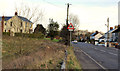
The Old Belfast Road, Bangor
Running from Springhill to Clandeboye, the Old Belfast Road has been bypassed by the Belfast Road dual carriageway since the early/mid-1970’s. Now mainly a local road serving the immediate area. The view is towards Springhill from near the Clandeboye end. There are a few fields (left), on the northern side, remaining undeveloped in what is otherwise mainly suburban housing.
Image: © Albert Bridge
Taken: 3 Jan 2012
0.22 miles