IMAGES TAKEN NEAR TO
Newtownards Road, BANGOR, BT19 1XZ
Introduction
This page details the photographs taken nearby to Newtownards Road, BT19 1XZ by members of the Geograph project.
The Geograph project started in 2005 with the aim of publishing, organising and preserving representative images for every square kilometre of Great Britain, Ireland and the Isle of Man.

There are currently over 7.5m images from over14,400 individuals and you can help contribute to the project by visiting https://www.geograph.org.uk
Image Map
Images are licensed for reuse under creativecommons.org/licenses/by-sa/2.0
Notes
- Clicking on the map will re-center to the selected point.
- The higher the marker number, the further away the image location is from the centre of the postcode.
Image Listing (14 Images Found)
Images are licensed for reuse under creativecommons.org/licenses/by-sa/2.0
Image
Details
Distance
1
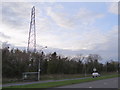
Bus stop and pylon on Bangor Road
The power line continues over the road.
Image: © Ian Paterson
Taken: 9 Apr 2014
0.09 miles
2
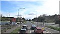
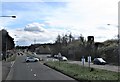
The Balloo Avenue Cross Roads on the A21 (Newtownards Road)
Image: © Eric Jones
Taken: 17 Apr 2017
0.10 miles
3
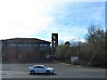
NIF&RS Station, Newtownards Road, Bangor
Image: © Eric Jones
Taken: 17 Apr 2017
0.10 miles
4
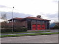
Bangor Fire Station
View of the Fire Station on Bangor Road.
Image: © Ian Paterson
Taken: 9 Apr 2014
0.11 miles
5
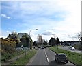
Approaching Bangor's NIF&RS Station on the Newtownards Road
The tower of the fire station can be seen on the right.
Image: © Eric Jones
Taken: 17 Apr 2017
0.11 miles
6
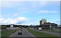
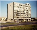
Approaching the Rathgael Roundabout on the Newtownards Road in Bangor
The multi-floored building on the left houses the offices of Northern Ireland's Education Department.
Image: © Eric Jones
Taken: 17 Apr 2017
0.15 miles
7
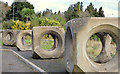
Concrete cubes, Bangor
Part of a row of honeycomb concrete cubes, in use as barrier between a church and a vacant site, on the Rathgael Road. They have more than a passing resemblance to those used in the building of the breakwater at Bangor harbour Image
Image: © Albert Bridge
Taken: 26 Nov 2012
0.15 miles
8
The A21 approaching the Rathgael Roundabout from the direction of Newtownards
The tall building on the right houses the offices of the Northern Ireland's Department of Education.
Image: © Eric Jones
Taken: 17 Apr 2017
0.19 miles
9
Department of Education offices, Balloo Road, in 1986
Image: © David Gearing
Taken: Unknown
0.20 miles
10
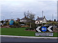
No caption required
This is the Newtownards Road Roundabout. Does exactly what it says on the label! I like the blue navigation buoys.
Image: © Ian Paterson
Taken: 9 Apr 2014
0.23 miles