IMAGES TAKEN NEAR TO
Old Windmill Road, BANGOR, BT19 1XH
Introduction
This page details the photographs taken nearby to Old Windmill Road, BT19 1XH by members of the Geograph project.
The Geograph project started in 2005 with the aim of publishing, organising and preserving representative images for every square kilometre of Great Britain, Ireland and the Isle of Man.

There are currently over 7.5m images from over14,400 individuals and you can help contribute to the project by visiting https://www.geograph.org.uk
Image Map
Images are licensed for reuse under creativecommons.org/licenses/by-sa/2.0
Notes
- Clicking on the map will re-center to the selected point.
- The higher the marker number, the further away the image location is from the centre of the postcode.
Image Listing (62 Images Found)
Images are licensed for reuse under creativecommons.org/licenses/by-sa/2.0
Image
Details
Distance
1
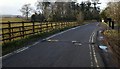
Old Windmill Road, Crawfordsburn
Old Windmill Road - otherwise known as the exit road from Crawfordsburn Country Park. It also serves a number of private dwellings along the road.
Image: © Rossographer
Taken: 18 Mar 2010
0.03 miles
2
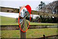
Mirror, Crawfordsburn
Traffic-sighting mirror, opposite a private entrance, on the Old Windmill Road Image
Image: © Albert Bridge
Taken: 25 Jan 2011
0.03 miles
3
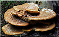
Fungus, Crawfordsburn 2011-1
Growing on dead wood, under beech, in Crawfordsburn Country Park.
Image: © Albert Bridge
Taken: 19 May 2011
0.06 miles
4
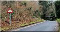
Height-restriction sign, Crawfordsburn
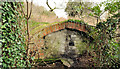
A 12ft height-restriction sign, on the Old Windmill Road Image, for inward traffic approaching this bridge Image (middle right). The Old Windmill Road allows access, through the park, to a number of houses outside the grounds.
Image: © Albert Bridge
Taken: 25 Jan 2011
0.06 miles
5
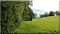
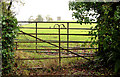
Field and trees, Crawfordsburn Country Park (7)
A field and trees, on the other side of this gate Image, near the Old Windmill Road. The vantage point is in the park. The field is outside it.
Image: © Albert Bridge
Taken: 31 May 2011
0.07 miles
6
Culvert, Crawfordsburn Country Park (2)
A culvert, under the path from this footbridge Image to the Old Windmill Road, just upstream of this one Image
Image: © Albert Bridge
Taken: 31 May 2011
0.07 miles
7
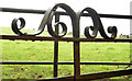
Two gates, Crawfordsburn (2)
Fancy ironwork on the gate nearest the camera in Image
Image: © Albert Bridge
Taken: 22 Oct 2013
0.08 miles
8
Two gates, Crawfordsburn (1)
Two gates, at the entrance to a field, between this footbridge Image and the Old Windmill Road. The windmill stump Image is in the background. Image shows some of the fancy ironwork.
Image: © Albert Bridge
Taken: 22 Oct 2013
0.08 miles
9
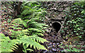
Old hut, Crawfordsburn Country Park
An old brick hut, blocked up at the southern end, close to this bridge Image, in Crawfordsburn Country Park. It has the appearance of a WWI relic but might be something entirely different. Further information welcome.
Image: © Albert Bridge
Taken: 21 Feb 2012
0.08 miles
10
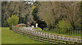
The Old Windmill Road, Crawfordsburn
See Image A different view of the road, looking down into the park towards here Image (close to the car in the background). The old windmill Image is out of picture to the left.
Image: © Albert Bridge
Taken: 25 Apr 2012
0.09 miles