1
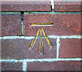
Bench Mark, Bangor
Cut bench mark on the south-eastern edge of Carnalea Methodist Church
Image in Bangor.
See also http://www.geograph.org.uk/search.php?i=11037856 for many other examples I have found.
Image: © Rossographer
Taken: 10 Mar 2010
0.10 miles
2
Carnalea Methodist Church, Bangor
Methodist church on the Crawfordsburn Road, Bangor, at the junction with Killaire Park.
Image: © Rossographer
Taken: 10 Mar 2010
0.11 miles
3
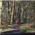
Woodland path, Bangor
Footpath leading from the Crawfordsburn Road to the North Down Coastal Path at Carnalea in Bangor.
Image: © Rossographer
Taken: 1 Mar 2020
0.13 miles
4
Pillar box, Carnalea, Bangor
EIIR pillar box (BT19 610), on the Station Road, close to Marlborough Drive (background).
Image: © Albert Bridge
Taken: 26 May 2012
0.14 miles
5
Downhill Avenue, Carnalea
A quiet and badly surfaced laneway off Killaire Park in Bangor's Carnalea area. Provides pedestrian access to Marlborough Park.
Image: © Dean Molyneaux
Taken: 16 Aug 2009
0.17 miles
6
Letter box, Carnalea, Bangor
Post-mounted EIIR letter box at Worcester Avenue, off the Crawfordsburn Road. The West Church
Image is in the background.
Image: © Albert Bridge
Taken: 15 Sep 2011
0.18 miles
7
Crawfordsburn Road near Bangor [2]
Looking towards Carnalea on the edge of Bangor. Lowry Hill is to the left.
Image: © Rossographer
Taken: 16 Apr 2008
0.20 miles
8
The "Bear of St Gall", Bangor
A recently-unveiled carving of a bear, at St Gall’s (CoI) parish church
Image (background), overlooking the Crawfordsburn Road
Image To quote from the church’s website “The story of St Gall tells of when he travelled in the woods of what is now Switzerland he was sitting one evening warming his hands at a fire. Suddenly a bear emerged from the woods and charged. The story goes that the holy man rebuked the bear and so awed by his presence it stopped its attack and slunk off in to the trees. There it gathered some firewood before returning to share the heat of the fire with St Gall. The legend says that for the rest of his days St Gall was followed around by his companion the bear”.
Image: © Albert Bridge
Taken: 25 Apr 2012
0.20 miles
9
The West Church, Bangor
The West (Presbyterian) Church at Rathmore was built in 1963 to a design by W McK Davidson. Too late for the Festival of Britain, too early for the swinging sixties, it would look out of place in a mill village or market town centre but suits the (then) new suburbs well – overall not a bad piece of sixties architecture.
Image: © Albert Bridge
Taken: 27 Sep 2007
0.21 miles
10
"Wavin" access cover, Carnalea, Bangor
A Wavin http://www.wavin.com/com/index.html cover, on what might be stop valve, on the Station Road.
Image: © Albert Bridge
Taken: 26 May 2012
0.22 miles


![Crawfordsburn Road near Bangor [2]](https://s2.geograph.org.uk/photos/76/72/767278_3cac49fc_120x120.jpg)


