IMAGES TAKEN NEAR TO
Ballysallagh Road, BANGOR, BT19 1UT
Introduction
This page details the photographs taken nearby to Ballysallagh Road, BT19 1UT by members of the Geograph project.
The Geograph project started in 2005 with the aim of publishing, organising and preserving representative images for every square kilometre of Great Britain, Ireland and the Isle of Man.

There are currently over 7.5m images from over14,400 individuals and you can help contribute to the project by visiting https://www.geograph.org.uk
Image Map
Images are licensed for reuse under creativecommons.org/licenses/by-sa/2.0
Notes
- Clicking on the map will re-center to the selected point.
- The higher the marker number, the further away the image location is from the centre of the postcode.
Image Listing (1 Images Found)
Images are licensed for reuse under creativecommons.org/licenses/by-sa/2.0
Image
Details
Distance
1
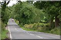
The Ballysallagh Road near Bangor
See Image This is the continuation of the road, in this square. A pleasant road, from behind the steering wheel, but the cars seem a bit too fast and close for comfort when on foot. This was taken early on a Sunday morning when the traffic was light. The view is towards Craigantlet.
Image: © Albert Bridge
Taken: 24 Jun 2007
0.02 miles