IMAGES TAKEN NEAR TO
Estate Road, BANGOR, BT19 1UR
Introduction
This page details the photographs taken nearby to Estate Road, BT19 1UR by members of the Geograph project.
The Geograph project started in 2005 with the aim of publishing, organising and preserving representative images for every square kilometre of Great Britain, Ireland and the Isle of Man.

There are currently over 7.5m images from over14,400 individuals and you can help contribute to the project by visiting https://www.geograph.org.uk
Image Map
Images are licensed for reuse under creativecommons.org/licenses/by-sa/2.0
Notes
- Clicking on the map will re-center to the selected point.
- The higher the marker number, the further away the image location is from the centre of the postcode.
Image Listing (4 Images Found)
Images are licensed for reuse under creativecommons.org/licenses/by-sa/2.0
Image
Details
Distance
1
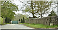
The Estate Road, Clandeboye, Bangor (May 2018)
See Image The Estate Road as it enters the Clandeboye Estate. The name sign (lower right) reads “Estate Road Clandeboye”.
Image: © Albert Bridge
Taken: 7 May 2018
0.19 miles
2
![Crawfordsburn Road, Clandeboye [2]](https://s0.geograph.org.uk/photos/75/47/754780_049a97f2_120x120.jpg)
Crawfordsburn Road, Clandeboye [2]
Looking towards Bangor.
Image: © Rossographer
Taken: 6 Apr 2008
0.20 miles
3
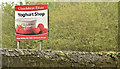
Clandeboye Estate Yoghurt Shop sign, Clandeboye, Bangor (May 2018)
A Clandeboye yoghurt http://www.clandeboye.co.uk/our-venue/clandeboye-yoghurt sign, beside the Crawfordsburn Road, close to here Image
Image: © Albert Bridge
Taken: 7 May 2018
0.21 miles
4
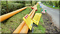
Gas pipes, Ballyleidy, Bangor (May 2018)
Gas pipes, along the Estate Road Image, to be laid as part of a new gas main beside the Ballysallagh Road (background).
Image: © Albert Bridge
Taken: 7 May 2018
0.24 miles