IMAGES TAKEN NEAR TO
Kilcooley Square, BANGOR, BT19 1SH
Introduction
This page details the photographs taken nearby to Kilcooley Square, BT19 1SH by members of the Geograph project.
The Geograph project started in 2005 with the aim of publishing, organising and preserving representative images for every square kilometre of Great Britain, Ireland and the Isle of Man.

There are currently over 7.5m images from over14,400 individuals and you can help contribute to the project by visiting https://www.geograph.org.uk
Image Map
Images are licensed for reuse under creativecommons.org/licenses/by-sa/2.0
Notes
- Clicking on the map will re-center to the selected point.
- The higher the marker number, the further away the image location is from the centre of the postcode.
Image Listing (9 Images Found)
Images are licensed for reuse under creativecommons.org/licenses/by-sa/2.0
Image
Details
Distance
1
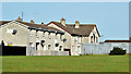
Ballynoe Gardens, Bangor (October 2014)
Ballynoe Gardens is part of the Kilcooley estate. The estate was built over a period in the 1960’s/70’s when large estates were fashionable and green spaces such as that in the foreground and here Image were automatic provisions. It housed mainly what was called “overspill” from east Belfast. At the time of planning and construction officialdom considered that Belfast had reached its maximum size and was unlikely to see any significant new development – a doubtful concept as we now know. The 1970 Development Plan makes interesting reading (with hindsight).
Image: © Albert Bridge
Taken: 2 Oct 2014
0.11 miles
2
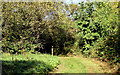
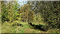
Kilcooley Wood, Bangor - October 2014(1)
Part of the wood to the south east of Drumhirk Drive.
Image: © Albert Bridge
Taken: 2 Oct 2014
0.16 miles
3
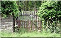
Old estate gate, Bangor (July 2015)
A rusty old iron gate, now disused and replaced by a fence, in the Clandeboye Estate wall beside the Rathgael Road.
Image: © Albert Bridge
Taken: 22 Jul 2015
0.19 miles
4
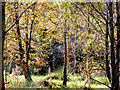
Kilcooley Wood, Bangor - October 2014(3)
Part of the wood, close to the Rathgael Road, to the north west of Drumhirk Drive.
Image: © Albert Bridge
Taken: 2 Oct 2014
0.21 miles
5
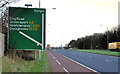
Advance direction sign, Bangor
An advance direction sign, on the Belfast Road Image, approaching the flyover Image and the ring road Image
Image: © Albert Bridge
Taken: 3 Jan 2012
0.22 miles
6
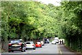
The Rathgael Road, Bangor (July 2015)
The Rathgael Road offers a handy shortcut, between the Belfast and Newtownards Roads, to the south of the ring road. The view is towards the former from near Woodgate. Clandeboye House Image and Estate http://www.clandeboye.co.uk/ are behind the wall and trees on the left.
Image: © Albert Bridge
Taken: 22 Jul 2015
0.23 miles
7
Kilcooley Wood, Bangor - October 2014(2)
Part of the wood to the north west of Drumhirk Drive.
Image: © Albert Bridge
Taken: 2 Oct 2014
0.23 miles
8
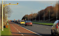
The Belfast Road near Clandeboye, Bangor
The dual carriageway section of the Belfast Road, on the Bangor side of Image, showing another of the average-speed cameras used to enforce the 60mph speed limit.
Image: © Albert Bridge
Taken: 3 Jan 2012
0.23 miles
9
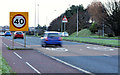
Speed limit sign, Bangor (2)
After the 60 Image, the speed limit reduces to 40mph as the Belfast Road Image approaches the flyover Image and the ring road Image following Image The signs are supported by road markings.
Image: © Albert Bridge
Taken: 3 Jan 2012
0.24 miles