IMAGES TAKEN NEAR TO
Moore Drive, BANGOR, BT19 1LQ
Introduction
This page details the photographs taken nearby to Moore Drive, BT19 1LQ by members of the Geograph project.
The Geograph project started in 2005 with the aim of publishing, organising and preserving representative images for every square kilometre of Great Britain, Ireland and the Isle of Man.

There are currently over 7.5m images from over14,400 individuals and you can help contribute to the project by visiting https://www.geograph.org.uk
Image Map
Images are licensed for reuse under creativecommons.org/licenses/by-sa/2.0
Notes
- Clicking on the map will re-center to the selected point.
- The higher the marker number, the further away the image location is from the centre of the postcode.
Image Listing (111 Images Found)
Images are licensed for reuse under creativecommons.org/licenses/by-sa/2.0
Image
Details
Distance
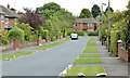
1
Carolsteen Park, Helen's Bay
A 1970’s development off the Bridge Road. The name comes from the builder, McCarroll and Steenson Limited, which had built Image a few years earlier.
Image: © Albert Bridge
Taken: 6 Aug 2013
0.07 miles
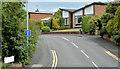
2
Blackwood Crescent, Helen's Bay
A loop of detached houses, off the Bridge Road. The name comes from the Blackwood family, hereditary owners of the Clandeboye Estate in which Helen’s Bay is built. This was one of the best-known members Image
Image: © Albert Bridge
Taken: 6 Aug 2013
0.10 miles
3
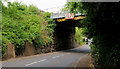
Railway bridge, Helen's Bay (1)
The bridge from the Belfast side.
Image: © Albert Bridge
Taken: 7 Jul 2010
0.10 miles
4
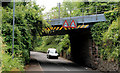
Railway bridge, Helen's Bay (2)
The bridge from the Helen’s Bay side.
Image: © Albert Bridge
Taken: 7 Jul 2010
0.10 miles
5
Railway bridge, Helen's Bay (3)
The “bridge strike” sign on the Belfast side.
Image: © Albert Bridge
Taken: 7 Jul 2010
0.10 miles
6
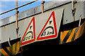
Railway bridge, Helen's Bay (5)
The height restriction sign (Belfast side).
Image: © Albert Bridge
Taken: 7 Jul 2010
0.10 miles
7
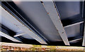
Railway bridge, Helen's Bay (4)
The underside of the bridge.
Image: © Albert Bridge
Taken: 7 Jul 2010
0.10 miles
8
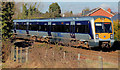
Former level crossing, Helen's Bay
There was an accommodation crossing at the site of the fence (lower left). It was closed (to the best of my memory) when the line was re-laid Image The train is the 10.45 Portadown – Bangor.
Image: © Albert Bridge
Taken: 1 Mar 2011
0.10 miles
9
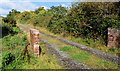
Lane, Helen's Bay/Crawfordsburn (1)
See Image The lane continues past farmland, close to the Bridge Road Image before joining it opposite the entrance to Crawfordsburn Country Park.
Image: © Albert Bridge
Taken: 20 Sep 2010
0.11 miles
10
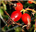
Rosehips, Helen's Bay
Rosehips, on a bush in the hedge, between the continuation of this lane Image and the railway.
Image: © Albert Bridge
Taken: 20 Sep 2010
0.12 miles