IMAGES TAKEN NEAR TO
Fort Road, BANGOR, BT19 1LA
Introduction
This page details the photographs taken nearby to Fort Road, BT19 1LA by members of the Geograph project.
The Geograph project started in 2005 with the aim of publishing, organising and preserving representative images for every square kilometre of Great Britain, Ireland and the Isle of Man.

There are currently over 7.5m images from over14,400 individuals and you can help contribute to the project by visiting https://www.geograph.org.uk
Image Map
Images are licensed for reuse under creativecommons.org/licenses/by-sa/2.0
Notes
- Clicking on the map will re-center to the selected point.
- The higher the marker number, the further away the image location is from the centre of the postcode.
Image Listing (79 Images Found)
Images are licensed for reuse under creativecommons.org/licenses/by-sa/2.0
Image
Details
Distance
1
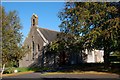
Parish church, Helen's Bay
The CoI parish church of St John Baptist, in Fort Road, was built in 1902.
Image: © Albert Bridge
Taken: 16 Oct 2007
0.07 miles
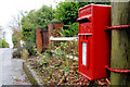
2
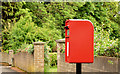
Pressed-steel postbox BT19 701, Helen's Bay (June 2014)
See Image Another EIIR post-mounted pressed-steel box (BT19 701), on the Fort Road, almost opposite Sheridan Drive. It replaced this one Image Continue to Image
Image: © Albert Bridge
Taken: 4 Jun 2014
0.07 miles
3
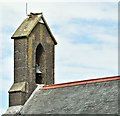
Church Bell, Helen's Bay (May 2016)
Bell, bell tower and lightning conductor on the Church of Ireland parish church of St John Baptist http://www.geograph.org.uk/search.php?i=63190321, Fort Road.
Image: © Albert Bridge
Taken: 18 May 2016
0.07 miles
4
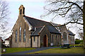
Church of St John Baptist, Helen's Bay
Church of Ireland parish church on Fort Road, Helen's Bay.
Image: © Rossographer
Taken: 3 Mar 2010
0.09 miles
5
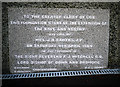
Foundation stone, Church of St. John the Baptist, Helen's Bay
Foundation stone on Image commemorating the extension of the church in 1964. There is probably some writing beneath "E.C.L. Dunne" but some recent
drainage work around the church has unhelpfully obscured it.
Image: © Rossographer
Taken: 3 Mar 2010
0.10 miles
6
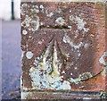
Bench Mark, Helen's Bay
Cut bench mark located on the northern side of the Church of St. John the Baptist, Helen's Bay Image
See also http://www.geograph.org.uk/search.php?i=11037856 for many other examples I have found.
Image: © Rossographer
Taken: 3 Mar 2010
0.10 miles
7
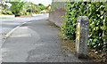
Fire hydrant post, Helen's Bay (May 2016)
A fire hydrant marker post, opposite Sheridan Drive, on the Fort Road.
Image: © Albert Bridge
Taken: 18 May 2016
0.14 miles
8
Letter box, Helen's Bay
EIIR box, on the Fort Road, mounted on what looks like the stump of an old telegraph pole. Subsequently replaced by Image
Image: © Albert Bridge
Taken: 12 Jan 2011
0.16 miles
9
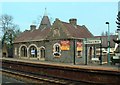
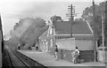
Helen's Bay Railway Station
This grand Scottish Baronial style station was the creation of Lord Dufferin, through whose land the line was laid. The flowers are in memory of Andrew James Fisher, a teenager fatally injured when he fell under a train here in April 2004.
Image: © Michael Parry
Taken: 23 Apr 2005
0.17 miles