IMAGES TAKEN NEAR TO
Burnside Park, BANGOR, BT19 1JW
Introduction
This page details the photographs taken nearby to Burnside Park, BT19 1JW by members of the Geograph project.
The Geograph project started in 2005 with the aim of publishing, organising and preserving representative images for every square kilometre of Great Britain, Ireland and the Isle of Man.

There are currently over 7.5m images from over14,400 individuals and you can help contribute to the project by visiting https://www.geograph.org.uk
Image Map
Images are licensed for reuse under creativecommons.org/licenses/by-sa/2.0
Notes
- Clicking on the map will re-center to the selected point.
- The higher the marker number, the further away the image location is from the centre of the postcode.
Image Listing (18 Images Found)
Images are licensed for reuse under creativecommons.org/licenses/by-sa/2.0
Image
Details
Distance
1
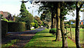
Meadow Way near Helen's Bay (6)
Meadow way at Meadow Way, Crawfordsburn, to the south east of Helen’s Bay. The lane is surfaced and the verges are mown.
Image: © Albert Bridge
Taken: 20 Sep 2010
0.10 miles
2
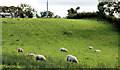
Field, Crawfordsburn
Part of a field, grazed by sheep, on the eastern side of Meadow Way Image
Image: © Albert Bridge
Taken: 20 Sep 2010
0.14 miles
3
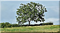
Tree, Ballymullan, Crawfordsburn (August 2017)
A hilltop tree on the western side of the Cootehall Road.
Image: © Albert Bridge
Taken: 17 Aug 2017
0.19 miles
4
Meadow Way near Helen's Bay (5)
Meadow way as it approaches Meadow Way, Crawfordsburn, to the south east of Helen’s Bay.
Image: © Albert Bridge
Taken: 20 Sep 2010
0.22 miles
5
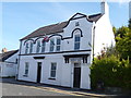
Orange Hall, Crawfordsburn
Located in Main Street.
Image: © Michael Dibb
Taken: 9 Jun 2015
0.23 miles
6
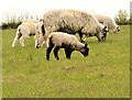
Sheep, Crawfordsburn (2)
Part of a flock grazing in fields to the south of Main Street.
Image: © Albert Bridge
Taken: 25 Apr 2012
0.23 miles
7
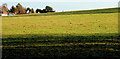
Field near Crawfordsburn (2)
Part of a large field, to the south west of Crawfordsburn village (background), on the other side of this gate Image
Image: © Albert Bridge
Taken: 19 Nov 2010
0.23 miles
8
![The Old Inn [2]](https://s2.geograph.org.uk/geophotos/04/55/27/4552794_96def126_120x120.jpg)
The Old Inn [2]
The thatched part of this large and historic hotel is thought to date back to the time of Queen Elizabeth I. Records show it was standing in its
present form in 1614, though substantial additions were made in the
mid-18th century and redevelopment in 2010. When Donaghadee was an important
cross channel port in the 17th and 18th centuries, the Old Inn was
conveniently situated for the mail coach from Belfast that connected
with the sailing packet, and horses were changed here. Consequently the inn has seen many famous visitors. There is a detailed history of the inn at http://www.bayburn.com/29128%20Helen's%20Bay%20&%20Crawfordsburn%20History.pdf pages 19-24
Image: © Michael Dibb
Taken: 9 Jun 2015
0.24 miles
9
![The Old Inn [1]](https://s0.geograph.org.uk/geophotos/04/55/27/4552792_746e7bf5_120x120.jpg)
The Old Inn [1]
The thatched part of this large and historic hotel is thought to date back to the time of Queen Elizabeth I. Records show it was standing in its
present form in 1614, though substantial additions were made in the
mid-18th century and redevelopment in 2010. When Donaghadee was an important
cross channel port in the 17th and 18th centuries, the Old Inn was
conveniently situated for the mail coach from Belfast that connected
with the sailing packet, and horses were changed here. Consequently the inn has seen many famous visitors. There is a detailed history of the inn at http://www.bayburn.com/29128%20Helen's%20Bay%20&%20Crawfordsburn%20History.pdf pages 19-24
Image: © Michael Dibb
Taken: 9 Jun 2015
0.24 miles
10
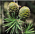
Larch cones, Crawfordsburn
Larch cones, still green, beside the Ballyrobert Road Image
Image: © Albert Bridge
Taken: 30 Jun 2011
0.24 miles