IMAGES TAKEN NEAR TO
Ballyrobert Road, BANGOR, BT19 1JS
Introduction
This page details the photographs taken nearby to Ballyrobert Road, BT19 1JS by members of the Geograph project.
The Geograph project started in 2005 with the aim of publishing, organising and preserving representative images for every square kilometre of Great Britain, Ireland and the Isle of Man.

There are currently over 7.5m images from over14,400 individuals and you can help contribute to the project by visiting https://www.geograph.org.uk
Image Map
Images are licensed for reuse under creativecommons.org/licenses/by-sa/2.0
Notes
- Clicking on the map will re-center to the selected point.
- The higher the marker number, the further away the image location is from the centre of the postcode.
Image Listing (197 Images Found)
Images are licensed for reuse under creativecommons.org/licenses/by-sa/2.0
Image
Details
Distance
1
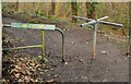
Turnstile, Crawfordsburn
A turnstile, at the village entrance to Crawfordsburn Country Park.
Image: © Albert Bridge
Taken: 12 Jan 2012
0.01 miles
2
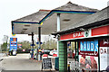
Spar and Topaz, Crawfordsburn - January 2017(1)
A Topaz petrol station and Spar shop at 90 Ballyrobert Road. I have no connection with the business but might just comment that the shop stocks items not usually found in most Spars or Eurospars. See also Image
Image: © Albert Bridge
Taken: 19 Jan 2017
0.01 miles
3
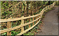
Fence, Crawfordsburn Country Park
A new fence on the western side of the glen, along the path from Crawfordsburn village.
Image: © Albert Bridge
Taken: 6 Mar 2012
0.01 miles
4
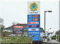
Spar and Topaz, Crawfordsburn - January 2017(2)
See Image The business, reported as opening on Christmas Eve 1955, is now the subject of a retirement sale.
Image: © Albert Bridge
Taken: 19 Jan 2017
0.02 miles
5
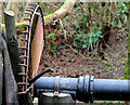
Pipe, Crawfordsburn
A pipe (which I take to be a water main), with an anti-climb device, in Crawfordsburn Glen behind the Old Inn Image
Image: © Albert Bridge
Taken: 25 Jan 2011
0.03 miles
6
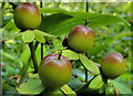
Tutsan berries, Crawfordsburn (7)
Ripening tutsan berries (looking like Granny Smith’s) growing near the waterfall.
Image: © Albert Bridge
Taken: 6 Sep 2012
0.04 miles
7
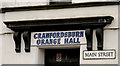
Main Street sign, Crawfordsburn
Standard style of street sign, at a fairly standard height, fixed to the wall of Crawfordsburn Orange Hall.
Image: © Albert Bridge
Taken: 25 Jan 2011
0.04 miles
8
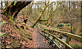
Path, Crawfordsburn Country Park (4)
See Image The path remains closed so that a circular walk, via the waterfall, is still not possible. This is the path on the western side of the glen. It might have been a mild winter but there is little to show it here.
Image: © Albert Bridge
Taken: 6 Mar 2012
0.04 miles
9
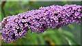
Buddleia, Crawfordsburn
Buddleia growing close to the Old Inn Image
Image: © Albert Bridge
Taken: 30 Jun 2011
0.04 miles
10
![The Old Inn [1]](https://s0.geograph.org.uk/geophotos/04/55/27/4552792_746e7bf5_120x120.jpg)
The Old Inn [1]
The thatched part of this large and historic hotel is thought to date back to the time of Queen Elizabeth I. Records show it was standing in its
present form in 1614, though substantial additions were made in the
mid-18th century and redevelopment in 2010. When Donaghadee was an important
cross channel port in the 17th and 18th centuries, the Old Inn was
conveniently situated for the mail coach from Belfast that connected
with the sailing packet, and horses were changed here. Consequently the inn has seen many famous visitors. There is a detailed history of the inn at http://www.bayburn.com/29128%20Helen's%20Bay%20&%20Crawfordsburn%20History.pdf pages 19-24
Image: © Michael Dibb
Taken: 9 Jun 2015
0.04 miles