IMAGES TAKEN NEAR TO
Main Street, BANGOR, BT19 1JF
Introduction
This page details the photographs taken nearby to Main Street, BT19 1JF by members of the Geograph project.
The Geograph project started in 2005 with the aim of publishing, organising and preserving representative images for every square kilometre of Great Britain, Ireland and the Isle of Man.

There are currently over 7.5m images from over14,400 individuals and you can help contribute to the project by visiting https://www.geograph.org.uk
Image Map
Images are licensed for reuse under creativecommons.org/licenses/by-sa/2.0
Notes
- Clicking on the map will re-center to the selected point.
- The higher the marker number, the further away the image location is from the centre of the postcode.
Image Listing (116 Images Found)
Images are licensed for reuse under creativecommons.org/licenses/by-sa/2.0
Image
Details
Distance
1
Main Street, Crawfordsburn
Main Street in the village of Crawfordsburn.
Image: © Rossographer
Taken: 30 Jun 2010
0.01 miles
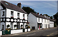
2
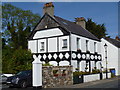
House with dovecot
This decorated house on Main Street, Crawfordsburn has a large dovecot.
Image: © Michael Dibb
Taken: 9 Jun 2015
0.03 miles
3

Lamppost, Crawfordsburn
Lamppost, in the Main Street beside Image, incorporating a bus stop sign and ornamental brackets for hanging baskets.
Image: © Albert Bridge
Taken: 12 Feb 2009
0.03 miles
4
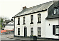
No 10 Main Street, Crawfordsburn (December 2018)
An end-of-terrace house due for renovation. The official description is “A terrace of two-storey and single-storey houses fronting Crawfordsburn Main Street, originally all single-storey and dating from the mid-nineteenth-century. The group has been compromised by significant alterations and refurbishments over the years such that it is of no interest”.
Image: © Albert Bridge
Taken: 28 Dec 2018
0.03 miles
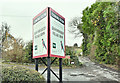
5
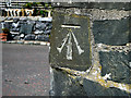
Bench Mark, Crawfordsburn
Cut bench mark on a wall at Main Street, Crawfordsburn.
The mark is 55.23 metres above MSL.
See also http://www.geograph.org.uk/search.php?i=11037856 for many other examples I have found.
Image: © Rossographer
Taken: 30 Jun 2010
0.03 miles
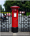
6

Pillar box, Crawfordsburn
A GVIR pillar box in the Main Street, close to the Old Inn Image
Image: © Albert Bridge
Taken: 12 Feb 2009
0.03 miles
7
Postbox, Crawfordsburn
George VI postbox on Main Street, Crawfordsburn (BT19 429). Also seen in Image
Image: © Rossographer
Taken: 30 Jun 2010
0.03 miles
8
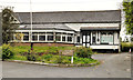
Former Crawfordsburn Country Club
The former Crawfordsburn Country Club (1937-2009) beside Main Street. There was a post-closure plan for demolition and replacement by apartments. To the best of my knowledge planning permission was refused in the light of local opposition.
Image: © Albert Bridge
Taken: 25 Apr 2012
0.03 miles
9
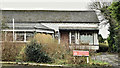
Former Crawfordsburn Country Club (January 2017)
The application for planning permission to redevelop the site is still under consideration. The NI planning portal shows a considerable number of representations from the public.
Image: © Albert Bridge
Taken: 19 Jan 2017
0.03 miles
10
Former Crawfordsburn Country Club site, Crawfordsburn (November 2018)
Now demolished. The replacement development “Crawfordsburn Village Brow” does not appear (at the time of submission) on the agents’ website.
Image: © Albert Bridge
Taken: 15 Nov 2018
0.03 miles