IMAGES TAKEN NEAR TO
Crawfordsburn Road, BANGOR, BT19 1HY
Introduction
This page details the photographs taken nearby to Crawfordsburn Road, BT19 1HY by members of the Geograph project.
The Geograph project started in 2005 with the aim of publishing, organising and preserving representative images for every square kilometre of Great Britain, Ireland and the Isle of Man.

There are currently over 7.5m images from over14,400 individuals and you can help contribute to the project by visiting https://www.geograph.org.uk
Image Map
Images are licensed for reuse under creativecommons.org/licenses/by-sa/2.0
Notes
- Clicking on the map will re-center to the selected point.
- The higher the marker number, the further away the image location is from the centre of the postcode.
Image Listing (38 Images Found)
Images are licensed for reuse under creativecommons.org/licenses/by-sa/2.0
Image
Details
Distance
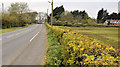
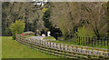
1
![Crawfordsburn Road near Bangor [1]](https://s1.geograph.org.uk/photos/76/72/767269_87f9818f_120x120.jpg)
Crawfordsburn Road near Bangor [1]
The Crawfordsburn Road heading towards Crawfordsburn from the edge of Bangor near Carnalea.
Image: © Rossographer
Taken: 16 Apr 2008
0.02 miles
2
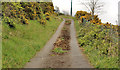
Track, Carnalea, Bangor
Image: © Albert Bridge
Taken: 25 Apr 2012
0.03 miles
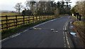
3
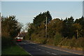
The Crawfordsburn Road, Bangor
The road from Bangor to Crawfordsburn is now almost entirely suburban. The short stretch near the entrance to Sharman Manor remains undeveloped. This is the view towards Crawfordsburn.
Image: © Albert Bridge
Taken: 2 Nov 2006
0.04 miles
4
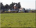
Sharman Manor near Crawfordsburn
House set back from the Crawfordsburn Road between Bangor and Crawfordsburn.
Image: © Rossographer
Taken: 16 Apr 2008
0.08 miles
5
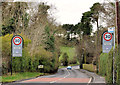
The Crawfordsburn Road, Crawfordsburn (2)
The Crawfordsburn Road on the Bangor side of Image Crawfordsburn Wood is on the right, at the wooden fence.
Image: © Albert Bridge
Taken: 21 Feb 2012
0.11 miles
6
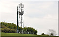
Telecoms mast, Carnalea, Bangor
A telecoms mast, in a field on the southern side of the Crawfordsburn Road Image
Image: © Albert Bridge
Taken: 25 Apr 2012
0.11 miles
7
The Crawfordsburn Road, Bangor (3)
The Crawfordsburn Road, with a well-cut hedge, looking towards here Image and Crawfordsburn. Sharman Manor Image is towards the top right.
Image: © Albert Bridge
Taken: 25 Apr 2012
0.13 miles
8
Old Windmill Road, Crawfordsburn
Old Windmill Road - otherwise known as the exit road from Crawfordsburn Country Park. It also serves a number of private dwellings along the road.
Image: © Rossographer
Taken: 18 Mar 2010
0.16 miles
9
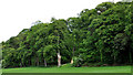
Trees, Crawfordsburn
A line of trees near the Old Windmill and Crawfordsburn Roads.
Image: © Albert Bridge
Taken: 19 May 2011
0.17 miles
10
The Old Windmill Road, Crawfordsburn
See Image A different view of the road, looking down into the park towards here Image (close to the car in the background). The old windmill Image is out of picture to the left.
Image: © Albert Bridge
Taken: 25 Apr 2012
0.17 miles