IMAGES TAKEN NEAR TO
Meadowvale Drive, BANGOR, BT19 1HP
Introduction
This page details the photographs taken nearby to Meadowvale Drive, BT19 1HP by members of the Geograph project.
The Geograph project started in 2005 with the aim of publishing, organising and preserving representative images for every square kilometre of Great Britain, Ireland and the Isle of Man.

There are currently over 7.5m images from over14,400 individuals and you can help contribute to the project by visiting https://www.geograph.org.uk
Image Map
Images are licensed for reuse under creativecommons.org/licenses/by-sa/2.0
Notes
- Clicking on the map will re-center to the selected point.
- The higher the marker number, the further away the image location is from the centre of the postcode.
Image Listing (9 Images Found)
Images are licensed for reuse under creativecommons.org/licenses/by-sa/2.0
Image
Details
Distance
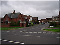
1
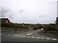
Meadowvale Avenue, Bangor
Quiet residential area in Bangor.
Image: © Rossographer
Taken: 23 Mar 2008
0.03 miles
2
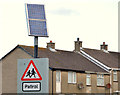
Solar panel, Bangor
A solar panel, powering the flashing lights on a “school” sign, on the Clandeboye Road, opposite Meadowvale.
Image: © Albert Bridge
Taken: 26 Nov 2012
0.16 miles
3
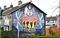
Battle of the Somme mural, Bangor
On a gable wall, at Owenroe Drive, facing the Clandeboye Road.
Image: © Albert Bridge
Taken: 26 Nov 2012
0.16 miles
4
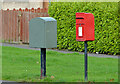
Letter box and drop box, Bangor
Drop box and post-mounted EIIR letter box (BT19 536) at Owenroe Drive, close to the Clandeboye Road.
Image: © Albert Bridge
Taken: 26 Nov 2012
0.17 miles
5
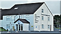
Free Presbyterian church, Bangor (February 2017)
Free Presbyterian church and Christian school http://independentchristianschool.org/ (half-term break today) at 277A Clandeboye Road.
Image: © Albert Bridge
Taken: 16 Feb 2017
0.18 miles
6
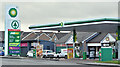
BP and Eurospar, Bangor (February 2017)
BP petrol station at the Eurospar on the Rathgael Road. The site also includes some independent shops.
Image: © Albert Bridge
Taken: 16 Feb 2017
0.21 miles
7
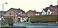
Ava Farm, Bangor (February 2017)
A small cul-de-sac of semis on the north western side of the Clandeboye Road. The development is built on land which was once part of the Clandeboye Estate http://www.clandeboye.co.uk/ home to the Marchioness of Dufferin and Ava https://en.wikipedia.org/wiki/Lindy_Hamilton-Temple-Blackwood,_Marchioness_of_Dufferin_and_Ava.
Image: © Albert Bridge
Taken: 16 Feb 2017
0.23 miles
8
Entrance to Lord Warden's Wood (housing development), from Rathgael Rd, looking S
Image: © Norman Ekin
Taken: 31 Aug 2007
0.23 miles
9
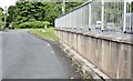
The Rathgael Road (old line), Bangor - July 2015 (2)
See Image The old line, on the south eastern of the Clandeboye Road, now a cul-de-sac for local use Image
Image: © Albert Bridge
Taken: 22 Jul 2015
0.24 miles