IMAGES TAKEN NEAR TO
Crawfordsburn Road, BANGOR, BT19 1GB
Introduction
This page details the photographs taken nearby to Crawfordsburn Road, BT19 1GB by members of the Geograph project.
The Geograph project started in 2005 with the aim of publishing, organising and preserving representative images for every square kilometre of Great Britain, Ireland and the Isle of Man.

There are currently over 7.5m images from over14,400 individuals and you can help contribute to the project by visiting https://www.geograph.org.uk
Image Map
Images are licensed for reuse under creativecommons.org/licenses/by-sa/2.0
Notes
- Clicking on the map will re-center to the selected point.
- The higher the marker number, the further away the image location is from the centre of the postcode.
Image Listing (4 Images Found)
Images are licensed for reuse under creativecommons.org/licenses/by-sa/2.0
Image
Details
Distance
1
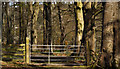
Gate, Clandeboye, Bangor
A gate, leading from Clandeboye Way to the Blackwood golf course.
Image: © Albert Bridge
Taken: 18 Apr 2012
0.15 miles
2
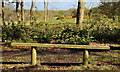
Seat, Clandeboye, Bangor
A seat, beside Clandeboye Way, overlooking the Blackwood golf course.
Image: © Albert Bridge
Taken: 18 Apr 2012
0.21 miles
3
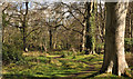
Clandeboye Way, Clandeboye, Bangor (3)
The Clandeboye Way path, looking towards the Crawfordsburn Road, in a typical part of the Barberino Wood.
Image: © Albert Bridge
Taken: 18 Apr 2012
0.21 miles
4
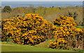
Whins, Clandeboye, Bangor (4)
Another great display of 2012 whins. This time on the Blackwood golf course, on the northern side of Clandeboye Way.
Image: © Albert Bridge
Taken: 18 Apr 2012
0.22 miles