IMAGES TAKEN NEAR TO
Pine Grove, HOLYWOOD, BT18 9SG
Introduction
This page details the photographs taken nearby to Pine Grove, BT18 9SG by members of the Geograph project.
The Geograph project started in 2005 with the aim of publishing, organising and preserving representative images for every square kilometre of Great Britain, Ireland and the Isle of Man.

There are currently over 7.5m images from over14,400 individuals and you can help contribute to the project by visiting https://www.geograph.org.uk
Image Map
Images are licensed for reuse under creativecommons.org/licenses/by-sa/2.0
Notes
- Clicking on the map will re-center to the selected point.
- The higher the marker number, the further away the image location is from the centre of the postcode.
Image Listing (14 Images Found)
Images are licensed for reuse under creativecommons.org/licenses/by-sa/2.0
Image
Details
Distance
1
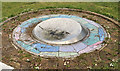
The Loughview Compass sculpture, Holywood
A sculpture, by Duncan Ross and Helen Sharp, on Jackson’s Road opposite the Old Holywood Road. Unveiled in April 2009 it’s now looking a bit forgotten/neglected.
Image: © Albert Bridge
Taken: 12 May 2012
0.08 miles
2
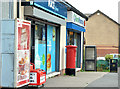
Pillar box, Holywood
EIIR pillar box (BT18 371) at the Loughview post office, Abbey Ring.
Image: © Albert Bridge
Taken: 27 Sep 2013
0.17 miles
3
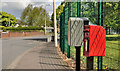
Letter box and drop box, Holywood
Post-mounted EIIR letter box (BT18 764) and drop box, outside Redburn Primary School, on the Old Holywood Road.
Image: © Albert Bridge
Taken: 12 May 2012
0.19 miles
4
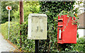
Drop box and postbox, Holywood
Post-mounted EIIR letter box (BT18 579) and a drop box, opposite Holywood Golf Club, on the Demesne Road. They can be seen at lower right in Image
Image: © Albert Bridge
Taken: 4 Oct 2013
0.20 miles
5
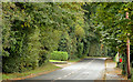
The Demesne Road, Holywood
The Demesne Road runs from the Church Road, around the eastern side of the town, towards Jackson’s Road on the south. This tree-lined stretch, seen from the corner of Abbot’s Wood, is on the approach to Holywood Golf Club (lower middle).
Image: © Albert Bridge
Taken: 4 Oct 2013
0.20 miles
6
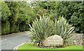
The entrance to Holywood Golf Club
The entrance to Holywood Golf Club http://www.holywoodgolfclub.co.uk/ on the Demesne Road. The entrance road and the 6th hole are called The Nun’s Walk. The name seems to come from a pre-Reformation convent which once occupied part of the site of Holywood House of 1605. See also Image
Image: © Albert Bridge
Taken: 4 Oct 2013
0.20 miles
7
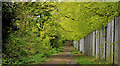
Path, Holywood (1)
A path, looking down towards Jackson’s Road and the Demesne Road, with a canopy of spring leaves. Holywood Golf Club is behind the fence on the right.
Image: © Albert Bridge
Taken: 12 May 2012
0.21 miles
8
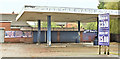
Former car wash, Old Holywood Road, Holywood (October 2017)
A former Maxol petrol station, long closed and, in recent times, used as a car wash. The site had the following planning permission (10 October 2012) “W/2007/0901/F Mixed use development comprising of 2 No ground floor retail units and 8 no. 2 bedroom apartments (amended plans submitted showing addition of boundary fence) Adjacent to 397a Old Holywood Road, Belfast [sic]”.
Image: © Albert Bridge
Taken: 16 Oct 2017
0.21 miles
9
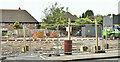
No 375 Old Holywood Road, Holywood (June 2019)
Demolished during the past week.
Image: © Albert Bridge
Taken: 8 Jun 2019
0.21 miles
10
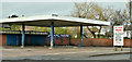
Former car wash, Old Holywood Road, Holywood (February 2019)
The car wash had re-opened but closed (again) recently. The site is the subject of a planning application for the construction of apartments (see the shared description (below).
The NI planning portal shows 17 representations and letters of objection.
This series of photographs appears as a matter of neutral record only.
I have no connection with the applicant or the objectors (individually or as a group) and express no opinion.
Image: © Albert Bridge
Taken: 20 Feb 2019
0.21 miles